Vancouver, British Columbia – August 14, 2025 – TheNewswire - Adamera Minerals Corp. (TSX-V: ADZ; OTC: DDNFF) ("Adamera" or the "Company") announces it has advanced targeting on its 18,714-hectare South Hedley Gold Property in B.C. Detailed soil sampling over the Max Prospect area has identified a zone with consistently anomalous gold values. Results from 46 soil samples collected last week, extended the gold anomaly further southeast and confirms a cut-off to the northwest. The anomaly remains open to the southeast where it becomes covered by an extensive cover of talus. Based on the data at this time, the exploration target may have a potential strike length of 500m.
Soil samples collected much further to the southeast also contain anomalous gold. One sample, located approximately 500 metres (“m”) southwest of the Max Prospect, contains 142 ppb gold (determined by fire assay at Activation Lab). Inversion of ground magnetic data over the immediate area shows a magnetic feature within a fault bound wedge that is coincident with the anomalous soils (20 to 1,300 ppb gold). The magnetic feature trends northwest-southeast for approximately 500m from the Max Prospect to the sample with 142ppb gold. This magnetic feature supports the northwest cut-off of gold in soil samples at the Max Prospect. See Figure 1 below.
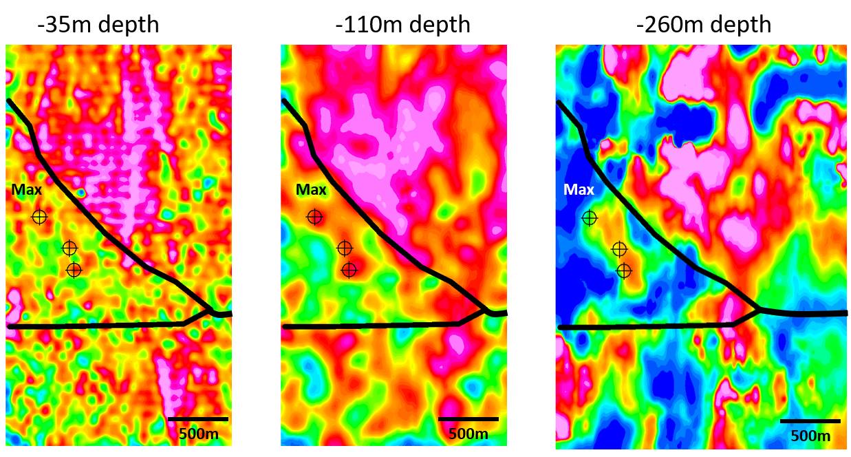 Figure 1. Magnetic inversion data over an area that includes the Max Prospect (shown as “Max” on the map). The three target symbols over the magnetic feature represent soil samples with anomalous gold. The most northerly target symbol is the Max Prospect, the two targets to the south are single soil anomalies that require immediate follow up. The three maps show the magnetic target becoming increasingly more cohesive with depth. This magnetic feature is fault bound (fault = heavy black lines) along the NE and is coincident with soil samples with anomalous gold. All three areas with soil samples are at an elevation of approximately 1,400 m.
Volcanic tuff is a dominant lithology capping the area. These tuffs are thought to be younger than the rocks that typically host gold mineralization in the area and as such are considered not to be prospective for gold. This is substantiated by the fact that our prospecting has found no old mines/prospects in this rock type. Soil samples with gold, evidence of quartz veining, presence of sulfides and rock alteration are restricted to areas that are topographically below the tuff. Therefore, it is the underlying “masked” rocks that have potential. Figure 2 is a graphic insight into our current exploration concept. The magnetic inversion data corroborates a possible primary gold source at depth.
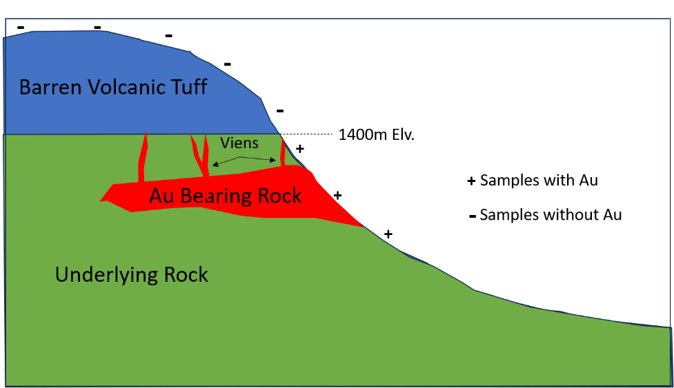 Figure 2. Conceptual Model for Exploration at the Max Prospect. The concept considers an overlying volcanic tuff “cap” that is younger than the underlying mineralized rocks of the area. Soil samples collected above the tuff would be barren (marked by “-”) and soil samples collected beneath the tuff and over the underlying mineralized rocks exposed in topographic lows would be more likely to contain gold (marked by “+”).
“We are making significant advances at the South Hedley Project as we push to expand the Max Prospect to the southeast. In fact, our data is suggestive of a target with potential strike length of 500m. The discovery of previously unknown gold apparently “leaking” from beneath an overlying tuff explains why the area has newly identified potential yet no evidence of previous exploration and/or mining. If we were not so close to a major gold camp we perhaps would have shrugged off the initial evidence we obtained. Follow up work will be immediate” says Mark Kolebaba, President and CEO of Adamera Minerals.
A total of 96 follow up soil samples were collected over the area in mid to late July and early August. The samples were analysed using the DetectORETM method. Several of these samples yielded highly anomalous gold results ranging from an approximated 100 to 1,300 ppb* gold. Sites with soil samples of 100 ppb* to greater than 1,000 ppb* gold are targeted for prospecting. Quartz veining and sulfide (arsenopyrite) bearing rocks have been identified and sampled at these localities. Results for several rock samples are pending.
A crew is scheduled to arrive on site at the end of the week. An exploration priority will be to collect additional soil samples over the area where a previous soil sample yielded 142 ppb gold. This area is located near the southeast end of the Max Prospect magnetic target which is approximately 500m from the Max Prospect. In addition, several other reconnaissance soil samples with anomalous gold that are located in topographic low areas on the property will be reviewed and followed up with respect to the conceptual exploration model mentioned above.
The Max Prospect is located in the northwest portion of the 100% owned property, between Whistle and Smith Creeks (see Figure 3). The site is unexplored, having been identified from reconnaissance soil sampling carried out by the Company. One soil sample yielded 1,340 ppb or 1.34 g/t gold. The prospect is coincident with newly discovered quartz-rhodonite veining in contact metamorphosed volcanic rocks. It also coincides with a prominent magnetic anomaly and a structural/topographic lineament that extends for several hundred metres.
Approximately 2.5 million ounces of gold** was reportedly produced in the Hedley Gold Camp. The Max Prospect is located less than 10 kilometres from Barrick Gold Corp’s past producer, the Nickel Plate Mine.
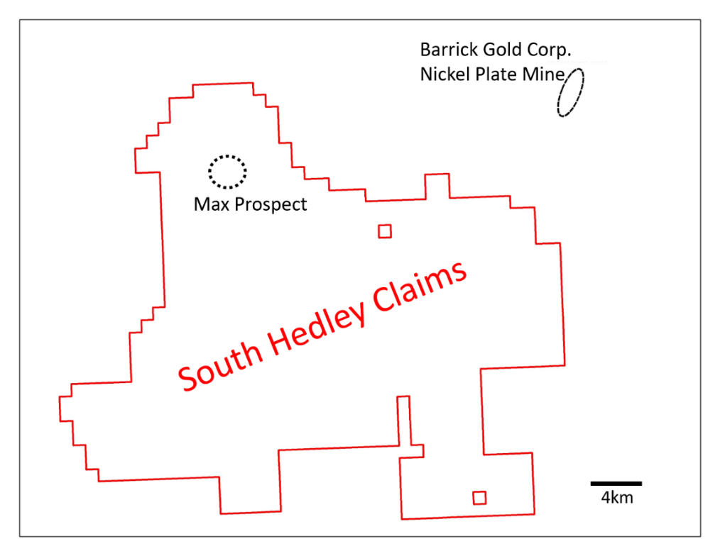 Figure 3. South Hedley Claims with Max Prospect located relative to Nickel Plate Mine.
Martin St Pierre (P.Geo.), qualified person under NI 43-101, is an independent consultant that has reviewed and approved data associated with this release.
Soil samples were analyzed in-house using the DetectORETM method for gold, a proprietary process developed by Portable PPB in Australia that allows for rapid gold analysis at ppb levels using a pXRF. The method uses a rigorous QA/QC process whereby a standard rock sample of known gold content is inserted every 30 samples at the preparation step. This sample is later analysed by the pXRF along with additional control samples that are tested every 20 analyses. The pXRF is fully automated and can analyse up to 180 samples per run. Each sample run using the pXRF is initiated by testing 5 control samples, if any samples do not pass the standard’s specifications, the XRF is immediately calibrated.
*The gold content of the discovery soil sample with 1,340 ppm gold was determined by fire assay of a 30-gram sample with atomic absorption finish at the Activation Laboratory in Kamloops. Adamera resampled the same site and analyzed 400 grams of soil using the DetectORETM method which yielded a comparable 1,361 DetectORE units representing a calculated ppb value.
** www2.gov.bc.ca/assets/gov/farming-natural-resources-and-industry/mineral-exploration-mining/documents/mineral-development-office/gold_september_2015.pdf
About Adamera
Adamera Minerals Corp. is exploring for a high-grade gold deposit in Canada and USA.
On behalf of the Board of Directors,
Mark Kolebaba
President & CEO
For additional information please contact:
Email: This email address is being protected from spambots. You need JavaScript enabled to view it.
Website: www.Adamera.com
Phone: (604) 689-2010
Neither TSX Venture Exchange nor its Regulation Services Provider (as that term is defined in policies of the TSX Venture Exchange) accepts responsibility for the adequacy or accuracy of this release. The TSX Venture Exchange has not reviewed and does not accept responsibility for the adequacy or accuracy of this release. Statements in this press release, other than purely historical information, including statements relating to the Company’s future plans and objectives or expected results, may include forward-looking statements. Forward-looking statements are based on numerous assumptions and are subject to all of the risks and uncertainties inherent in resource exploration and development. As a result, actual results may vary materially from those described in the forward-looking statements.