VANCOUVER, Sept. 28, 2016 /CNW/ - NexGen Energy Ltd. ("NexGen" or the "Company") (TSX:NXE, OTCQX:NXGEF) is pleased to report radioactivity results on seven holes from our ongoing summer drilling program on our 100% owned, Rook I property, Athabasca Basin, Saskatchewan.
Mineralized zones in the A1, A2 and A3 shears continue to be confirmed and rapidly expanded by drilling. In the higher grade A2 sub-zone (the "Sub-Zone"), AR-16-96c2 intersected dense accumulations of massive to semi-massive pitchblende both within and outside of the A2 High Grade Domain marked by 60.5 m of total composite mineralization including 13.4 m of off-scale radioactivity (>10,000 to >61,000 cps). In addition, AR-16-96c3 intersected 80.0 m of total composite mineralization including 12.45 m of off-scale radioactivity also in the A2 shear. A new zone of high grade mineralization has now been delineated outside the lower margin of the A2 High Grade Domain defined in the maiden Arrow Deposit 43-101 Inferred Mineral Resource estimate.
In the A3 shear, five holes have intersected strong mineralization in step outs as far as 70 m from the current resource domains. Hole AR-16-101c2 intersected 47.0 m of composite mineralization including 6.2 m of off-scale radioactivity within the A3 shear.
Furthermore, drilling in the new high grade zone within the A1 shear continues to return strong visible uranium mineralization where AR-16-102c2 intersected 44.5 m of total composite mineralization including 1.35 m of off-scale radioactivity 45 m northeast from the closest hole.
The successful and ongoing summer drill program has been extended to the end of October 2016.
Highlights:
A2 Higher Grade Domain and A2 shear
- Hole AR-16-96c2 (75 m down-dip and northeast from AR-15-44b) intersected 60.5 m of total composite mineralization including 13.4 m of total composite off-scale radioactivity (>10,000 to >61,000 cps) within a 101.5 m section (553.5 to 655.0 m), and featured 1.0 m of minimum-greater-than-61,000 cps in the Sub-Zone.
- Hole AR-16-96c3 (87 m down-dip and northeast from AR-15-44b) intersected 80.0 m of total composite mineralization including 12.45 m of total composite off-scale radioactivity (>10,000 to >61,000 cps) within a 139.5 m section (540.5 to 680.0 m).
A3 Shear
- Scissor hole AR-16-101c2 (52 m up-dip and northeast of AR-15-57c2) intersected 47.0 m of total composite mineralization including 6.2 m of total composite off-scale radioactivity (>10,000 to >61,000 cps) within an 89.0 m section (487.5 to 576.5 m).
- Scissor hole AR-16-102c1 (202 m up-dip and northeast of AR-15-57c2) intersected 47.5 m of total composite mineralization including 2.5 m of total composite off-scale radioactivity (>10,000 to >61,000 cps) within a 91.5 m section (366.0 to 457.5 m).
A1 Shear
- Scissor hole AR-16-102c2 (45 m up-dip and northeast of AR-16-91c3) intersected 24.0 m of total composite mineralization including 1.35 m of total composite off-scale radioactivity (>10,000 to 22,900 cps) within a 42.0 m section (595.0 to 637.0 m).
Table 1: Higher Grade A2 Sub-Zone Angled Drill Holes
|
2015 |
AR-15-59c22 |
AR-15-54c12 |
AR-15-58c12 |
AR-15-622 |
AR-15-44b2 |
AR-15-49c22 |
AR-15-57c32 |
|||
|
Total composite mineralization = |
75.5m |
42.0m |
86.0m |
143.0m |
135.6m |
73.5m |
62.5m |
|||
|
Total Off-scale (>10,000 to 29,999 cps)3 = |
11.4m |
5.9m |
14.3m |
17.8m |
30.3m |
15.7m |
4.4m |
|||
|
Total Off-scale (>30,000 to 60,999 cps)3 = |
4.5m |
3.0m |
3.9m |
10.6m |
7.8m |
5.2m |
2.5m |
|||
|
Total Off-scale (>61,000 cps)3 = |
1.0m |
0.5m |
2.0m |
2.0m |
1.5m |
2.2m |
1.8m |
|||
|
Continuous GT (Grade x Thickness) = |
371 |
277 |
200 and |
787 |
655 |
605 |
319 |
|||
|
Winter 2016 |
AR-16-81c32 |
AR-16-76c42 |
AR-16-76c12 |
AR-16-76c32 |
AR-16-63c12 |
AR-16-63c32 |
AR-16-86c12 |
AR-16-74c12 |
AR-16-63c22 |
AR-16-91c22 |
AR-16-64c32 |
AR-16-64c22 |
AR-16-64c12 |
AR-16-72c22 |
AR-16-78c12 |
AR-16-78c42 |
|||
|
Total composite mineralization = |
48.5m |
105.7m |
73.5m |
67.5m |
55.5m |
147.0m |
90.0m |
88.0m |
138.0m |
89.0m |
102.0m |
76.0m |
74.0m |
93.0m |
64.0m |
120.5m |
|||
|
Total Off-scale (>10,000 to 29,999 cps)3 = |
5.2m |
19.9m |
14.8m |
14.9m |
6.9m |
22.1m |
8.8m |
21.2m |
17.1m |
13.4m |
18.8m |
16.0m |
10.3m |
7.0m |
11.6m |
25.8m |
|||
|
Total Off-scale (>30,000 to 60,999 cps)3 = |
4.0m |
1.0m |
2.8m |
5.0m |
0.5m |
3.0m |
2.3m |
1.2m |
9.9m |
6.0m |
2.5m |
4.7m |
3.7m |
0.5m |
3.0m |
6.2m |
|||
|
Total Off-scale (>61,000 cps)3 = |
2.5m |
0.0m |
5.3m |
4.5m |
0.0m |
0.5m |
2.0m |
0.0m |
13.9m |
3.0m |
0.0m |
5.5m |
0.0m |
1.7m |
2.5m |
5.5m |
|||
|
Continuous GT (Grade x Thickness) = |
395 |
142 and |
762 |
761 |
203 |
274 and 124 |
394 |
160 and 35 |
638 and 604 |
514 |
172 and 92 |
541 |
338 |
156 and 45 |
485 |
660 and 88 and 67 |
|||
|
Summer 2016 |
AR-16-92c31 |
AR-16-98c21 |
AR-16-93c21 |
AR-16-96c2 |
|||
|
Total composite mineralization = |
49.5m |
85.0m |
69.5m |
60.5m |
|||
|
Total Off-scale (>10,000 to 29,999 cps)3 = |
7.1m |
3.3m |
8.15m |
8.9m |
|||
|
Total Off-scale (>30,000 to 60,999 cps)3 = |
1.4m |
1.0m |
1.5m |
3.5m |
|||
|
Total Off-scale (>61,000 cps)3 = |
2.3m |
5.75m |
1.5m |
1.0m |
|||
|
Continuous GT (Grade x Thickness) = |
Assays Pending |
Assays Pending |
Assays Pending |
Assays Pending |
|||
|
1 radioactivity results previously released |
|||||
|
2 radioactivity and assays results previously released |
|||||
|
3 minimum radioactivity using RS-120 gamma spectrometer |
Activities & Financial
- The mineralized zones at the land-based and basement hosted Arrow Deposit currently cover an area of approximately 870 m by 300 m with a vertical extent of mineralization commencing from 100 m to 920 m, and remains open in most directions and at depth.
- The seven rig summer 2016 program has been extended to the end of October 2016.
- The Company has cash on hand of approximately $85 million.
A drill hole location map and the A2 and A3 mineralized shear long sections are shown in Figures 1 to 3.
Garrett Ainsworth, Vice-President, Exploration and Development, commented: "These most recent drill results continue to swiftly prove up and expand mineralization at Arrow. Significant accumulations of massive to semi-massive pitchblende within and outside the lower margin of the high grade A2 domain is now anchored by several drill holes that were not included in the Arrow Deposit 43-101 Maiden Inferred Mineral Resource. We are also seeing significant expansion within the A1 and A3 shears where high grade intervals have been returned from significant step outs."
Leigh Curyer, Chief Executive Officer commented: "The seven rig summer 2016 drilling program has been extended to the end of October 2016 with the focus on continued Arrow infill, expansion and regional drilling along strike from Arrow along the Patterson Corridor. The 2016 drilling season is meeting and exceeding all objectives set at the commencement of the year."
Table 2: Arrow Deposit Drill Hole Data
|
Drill Hole |
Athabasca |
Handheld Scintillometer Results (RS-120) |
||||||||
|
Hole ID |
Azimuth |
Dip |
Total |
Unconformity |
From (m) |
To (m) |
Width (m) |
CPS Range |
||
|
AR-16-96c2 |
147 |
-73 |
855.00 |
108.00 |
400.50 |
401.50 |
1.00 |
<500 - 2300 |
||
|
408.50 |
414.00 |
5.50 |
<500 - 1100 |
|||||||
|
417.00 |
417.50 |
0.50 |
<500 - 780 |
|||||||
|
553.50 |
569.00 |
15.50 |
<500 - >61000 |
|||||||
|
571.50 |
609.50 |
38.00 |
<500 - >61000 |
|||||||
|
612.00 |
614.00 |
2.00 |
<500 - 48000 |
|||||||
|
618.50 |
619.00 |
0.50 |
<500 - 1200 |
|||||||
|
643.00 |
644.00 |
1.00 |
<500 - 950 |
|||||||
|
649.00 |
649.50 |
0.50 |
<500 - 500 |
|||||||
|
652.00 |
655.00 |
3.00 |
<500 - 680 |
|||||||
|
704.50 |
712.50 |
8.00 |
<500 - 4200 |
|||||||
|
735.00 |
735.50 |
0.50 |
<500 - 510 |
|||||||
|
738.00 |
739.00 |
1.00 |
<500 - 1450 |
|||||||
|
747.50 |
748.00 |
0.50 |
<500 - 550 |
|||||||
|
754.00 |
754.50 |
0.50 |
<500 - 1500 |
|||||||
|
759.00 |
761.00 |
2.00 |
<500 - 26000 |
|||||||
|
764.00 |
764.50 |
0.50 |
<500 - 520 |
|||||||
|
769.00 |
771.50 |
2.50 |
<500 - 3500 |
|||||||
|
775.00 |
776.50 |
1.50 |
<500 - 700 |
|||||||
|
782.00 |
783.00 |
1.00 |
<500 - 3600 |
|||||||
|
816.50 |
820.00 |
3.50 |
<500 - 1000 |
|||||||
|
826.50 |
827.00 |
0.50 |
<500 - 530 |
|||||||
|
AR-16-96c3 |
147 |
-73 |
1013.00 |
108.00 |
414.50 |
421.50 |
7.00 |
<500 - 700 |
||
|
540.50 |
559.50 |
19.00 |
<500 - >61000 |
|||||||
|
563.00 |
572.50 |
9.50 |
<500 - 34000 |
|||||||
|
577.00 |
580.50 |
3.50 |
<500 - >61000 |
|||||||
|
590.00 |
602.50 |
12.50 |
<500 - 20000 |
|||||||
|
605.00 |
606.50 |
1.50 |
<500 - 1300 |
|||||||
|
610.00 |
614.00 |
4.00 |
<500 - 22000 |
|||||||
|
616.50 |
617.00 |
0.50 |
<500 - 850 |
|||||||
|
621.00 |
628.00 |
7.00 |
<500 - 16500 |
|||||||
|
631.50 |
636.50 |
5.00 |
<500 - >61000 |
|||||||
|
644.50 |
652.00 |
7.50 |
<500 - 8300 |
|||||||
|
662.00 |
662.50 |
0.50 |
1300 - 4600 |
|||||||
|
668.00 |
668.50 |
0.50 |
<500 - 700 |
|||||||
|
671.00 |
680.00 |
9.00 |
<500 - 13000 |
|||||||
|
695.00 |
702.00 |
7.00 |
<500 - 3350 |
|||||||
|
707.00 |
708.00 |
1.00 |
<500 - 630 |
|||||||
|
722.50 |
723.00 |
0.50 |
510 - 2350 |
|||||||
|
773.00 |
773.50 |
0.50 |
<500 - 530 |
|||||||
|
811.00 |
811.50 |
0.50 |
<500 - 3000 |
|||||||
|
AR-16-101c1 |
327 |
-70 |
885.00 |
133.60 |
442.50 |
443.00 |
0.50 |
600 - 8600 |
||
|
450.00 |
454.00 |
4.00 |
<500 - 3400 |
|||||||
|
473.00 |
476.50 |
3.50 |
<500 - 5100 |
|||||||
|
480.00 |
481.25 |
1.25 |
<500 - 31000 |
|||||||
|
483.50 |
486.50 |
3.00 |
<500 - 7000 |
|||||||
|
490.00 |
490.50 |
0.50 |
800 - 3800 |
|||||||
|
506.00 |
526.00 |
20.00 |
<500 - 53000 |
|||||||
|
532.50 |
533.00 |
0.50 |
<500 - 620 |
|||||||
|
548.50 |
550.50 |
2.00 |
<500 - 750 |
|||||||
|
625.00 |
626.00 |
1.00 |
<500 - 560 |
|||||||
|
629.00 |
629.50 |
0.50 |
<500 - 1400 |
|||||||
|
643.00 |
648.50 |
5.50 |
<500 - 6600 |
|||||||
|
686.00 |
696.00 |
10.00 |
<500 - 2500 |
|||||||
|
701.00 |
705.50 |
4.50 |
<500 - 3000 |
|||||||
|
708.00 |
708.50 |
0.50 |
<500 - 560 |
|||||||
|
AR-16-101c2 |
327 |
-70 |
1008.00 |
133.60 |
458.00 |
459.00 |
1.00 |
<500 - 620 |
||
|
468.50 |
470.50 |
2.00 |
<500 - 3100 |
|||||||
|
487.50 |
488.00 |
0.50 |
<500 - 780 |
|||||||
|
504.00 |
504.50 |
0.50 |
<500 - 4500 |
|||||||
|
509.00 |
511.50 |
2.50 |
<500 - 14000 |
|||||||
|
523.00 |
534.50 |
11.50 |
<500 - 48000 |
|||||||
|
537.50 |
548.50 |
11.00 |
<500 - 47000 |
|||||||
|
553.00 |
554.00 |
1.00 |
<500 - 23000 |
|||||||
|
556.50 |
576.50 |
20.00 |
<500 - >61000 |
|||||||
|
649.50 |
659.00 |
9.50 |
<500 - 20000 |
|||||||
|
677.50 |
680.00 |
2.50 |
<500 - 1200 |
|||||||
|
687.00 |
689.00 |
2.00 |
<500 - 2600 |
|||||||
|
705.50 |
714.50 |
9.00 |
<500 - 2400 |
|||||||
|
720.00 |
724.00 |
4.00 |
<500 - 15000 |
|||||||
|
727.50 |
732.50 |
5.00 |
<500 - 5000 |
|||||||
|
775.50 |
776.00 |
0.50 |
<500 - 620 |
|||||||
|
AR-16-102c1 |
327 |
-70 |
840.00 |
129.60 |
366.00 |
371.00 |
5.00 |
<500 - 4050 |
||
|
377.50 |
379.00 |
1.50 |
<500 - 1450 |
|||||||
|
381.50 |
406.00 |
24.50 |
<500 - 28000 |
|||||||
|
409.00 |
424.00 |
15.00 |
<500 - >61000 |
|||||||
|
450.00 |
451.00 |
1.00 |
<500 - 600 |
|||||||
|
457.00 |
457.50 |
0.50 |
<500 - 520 |
|||||||
|
471.50 |
472.00 |
0.50 |
<500 - 570 |
|||||||
|
543.00 |
552.00 |
9.00 |
<500 - 20000 |
|||||||
|
557.50 |
558.00 |
0.50 |
<500 - 1900 |
|||||||
|
562.00 |
563.00 |
1.00 |
<500 - >61000 |
|||||||
|
570.00 |
576.50 |
6.50 |
<500 - 1400 |
|||||||
|
614.00 |
614.50 |
0.50 |
<500 - 520 |
|||||||
|
627.00 |
633.50 |
6.50 |
<500 - 1500 |
|||||||
|
664.00 |
665.50 |
1.50 |
<500 - 1350 |
|||||||
|
690.00 |
690.50 |
0.50 |
<500 - 1600 |
|||||||
|
702.00 |
702.50 |
0.50 |
<500 - 650 |
|||||||
|
707.00 |
712.00 |
5.00 |
<500 - 980 |
|||||||
|
714.50 |
718.50 |
4.00 |
<500 - 760 |
|||||||
|
722.00 |
735.00 |
13.00 |
<500 - 5200 |
|||||||
|
739.50 |
740.00 |
0.50 |
<500 - 1000 |
|||||||
|
AR-16-102c2 |
327 |
-70 |
987.00 |
129.60 |
365.00 |
371.50 |
6.50 |
<500 - 10500 |
||
|
379.00 |
393.00 |
14.00 |
<500 - 21000 |
|||||||
|
395.50 |
396.50 |
1.00 |
<500 - 14000 |
|||||||
|
401.00 |
401.50 |
0.50 |
<500 - 1600 |
|||||||
|
405.00 |
418.50 |
13.50 |
<500 - 29000 |
|||||||
|
436.00 |
437.50 |
1.50 |
<500 - 520 |
|||||||
|
455.00 |
455.50 |
0.50 |
<500 - 1500 |
|||||||
|
463.50 |
475.50 |
12.00 |
<500 - 5200 |
|||||||
|
519.00 |
527.50 |
8.50 |
<500 - 14500 |
|||||||
|
595.00 |
600.50 |
5.50 |
<500 - 22900 |
|||||||
|
605.00 |
612.00 |
7.00 |
<500 - 20000 |
|||||||
|
615.00 |
615.50 |
0.50 |
<500 - 925 |
|||||||
|
619.00 |
621.00 |
2.00 |
<500 - 13000 |
|||||||
|
624.00 |
632.00 |
8.00 |
<500 - 21000 |
|||||||
|
636.00 |
637.00 |
1.00 |
<500 - 1000 |
|||||||
|
AR-16-104c1 |
327 |
-70 |
852.00 |
120.80 |
527.50 |
528.00 |
0.50 |
800 - 5700 |
||
|
539.50 |
540.50 |
1.00 |
<500 - 1100 |
|||||||
|
547.50 |
548.00 |
0.50 |
<500 - 1600 |
|||||||
|
552.50 |
553.50 |
1.00 |
1000 - 32000 |
|||||||
|
568.00 |
569.00 |
1.00 |
<500 - 650 |
|||||||
|
635.50 |
647.00 |
11.50 |
<500 - >61000 |
|||||||
|
651.50 |
658.50 |
7.00 |
<500 - 6000 |
|||||||
|
663.00 |
663.50 |
0.50 |
<500 - 2300 |
|||||||
|
666.50 |
667.50 |
1.00 |
<500 - 1000 |
|||||||
|
670.00 |
670.50 |
0.50 |
600 - 20000 |
|||||||
|
674.50 |
680.50 |
6.00 |
<500 - 5000 |
|||||||
|
684.00 |
685.00 |
1.00 |
<500 - 2200 |
|||||||
|
689.00 |
694.50 |
5.50 |
<500 - 49000 |
|||||||
|
698.00 |
702.00 |
4.00 |
<500 - 14000 |
|||||||
|
706.00 |
709.50 |
3.50 |
<500 - 22000 |
|||||||
|
713.00 |
714.00 |
1.00 |
3500 - 31000 |
|||||||
|
719.00 |
720.50 |
1.50 |
<500 - 550 |
|||||||
|
724.50 |
729.00 |
4.50 |
<500 - 4700 |
|||||||
|
731.50 |
736.50 |
5.00 |
<500 - 12000 |
|||||||
|
758.00 |
761.50 |
3.50 |
<500 - 4900 |
|||||||
Parameters:
- Maximum internal dilution 2.00 m downhole
- All depths and intervals are meters downhole, true thicknesses are yet to be determined
- "Anomalous" means >500 cps (counts per second) total count gamma readings by gamma scintillometer type RS-120
- "Off-scale" means >10,000 cps (counts per second) total count gamma readings by gamma scintillometer type RS-120
- Where "Min cps" is <500 cps, this refers to local low radiometric zones within the overall radioactive interval.
ARROW DEPOSIT DRILLING
AR-16-96c2
Hole AR-16-96c2 was a directional hole that departed pilot hole AR-16-96c1 at a depth of 297 m. It tested the A2 shear 17 m down-dip and northeast of AR-16-72c2 (4.65% U3O8 over 33.5 m and 4.08% U3O8 over 11.0 m in the A2 shear) and the A3 shear 41 m up-dip and northeast of AR-15-56c2 (1.58% U3O8 over 32.0 m in the A3 shear). Directional drilling was initiated at 312 m. The A2 and A3 shears were intersected at inclinations of -72° and -71°, respectively.
Basement lithologies were intersected beginning at the top of the hole and consisted largely of semipelitic gneiss to granofel and relatively narrow intervals of pelitic gneiss and mylonite (the A1 through A3 shears). Anomalous to strongly anomalous radioactivity was intersected in the A1 through A3 shears in association with massive to semi-massive veins, stringers, disseminated and fracture-controlled pitchblende mineralization. A total composite mineralization of 89.5 m including 13.55 m of off-scale radioactivity (>10,000 to >61,000 cps) was intersected within a 426.5 m section (400.5 to 827.0 m). In the A1 shear zone, 7.0 m of composite mineralization was intersected. In the A2 shear, 60.5 m of composite mineralization including 13.4 m of off-scale radioactivity was intersected. In the A3 shear zone, 22.0 m of composite mineralization including 0.15 m of off-scale radioactivity was intersected. The hole was terminated at 855 m.
AR-16-96c3
Hole AR-16-96c3 was a directional hole that departed pilot hole AR-16-96c2 at a depth of 354 m. It tested the A2 shear 22 m down-dip from AR-16-96c1 (10.2 m of off-scale radioactivity the A2 shear; assays pending) and the A3 shear 25 m down-dip from the same hole. Directional drilling was initiated at 369 m. The A1 and A2 shears were intersected at -72° and -70°, respectively.
Basement lithologies were intersected beginning at the top of the hole and consisted largely of semipelitic gneiss to granofel and relatively narrow intervals of pelitic gneiss and mylonite (the A1 through A4 shears). Anomalous to strongly anomalous radioactivity was intersected in the A1 through A3 shears in association with massive to semi-massive veins, stringers, disseminated and fracture-controlled pitchblende mineralization. Total composite mineralization of 96.5 m including 12.45 m of off-scale radioactivity (>10,000 to >61,000 cps) was intersected within a 397.0 m section (414.5 to 811.5 m). In the A1 shear zone, 7.0 m of composite mineralization was intersected. In the A2 shear, 80.0 m of composite mineralization including 12.45 m of off-scale radioactivity was intersected. In the A3 shear, 9.5 m of composite mineralization was intersected. The hole was terminated at 1,013 m.
AR-16-101c1
Hole AR-16-101c1 was a directional hole collared from surface at an angled orientation (-70°) to the northwest (327° Azimuth). It was designed as a scissor hole to test and expand mineralized zones in the A2 and A3 shears. The hole tested the A2 shear 92 m down-dip and northeast from AR-14-15 (3.42% U3O8 over 22.35 m and 1.52% U3O8 over 32.0 m in the A2 shear) and the A3 shear 91 m up-dip and northeast of AR-15-57c2 (5.89% U3O8 over 29.5 m in the A3 shear). Directional drilling was initiated at 312 m. The A2 and A3 shears were both intersected at an inclination of -66°.
The hole intersected heavily bleached and desilicified Athabasca Group sandstones between 121.2 m and the unconformity at 133.6 m. Basement lithologies consisted largely of semipelitic gneiss to granofel and relatively narrow intervals of pelitic gneiss and mylonite (the A1 through A4 shears). Anomalous to strongly anomalous radioactivity was intersected in the A2 through A4 shears in association with stringers, disseminated and fracture-controlled pitchblende mineralization. A total composite mineralization of 57.25 m including 0.85 m of off-scale radioactivity (>10,000 to 53,000 cps) was intersected within a 266.0 m section (442.5 to 708.5 m). In the A2 shear, 22.0 m of composite mineralization was intersected. In the A3 shear, 30.75 m of composite mineralization including 0.85 m of off-scale radioactivity was intersected. In the A4 shear, 4.5 m of composite mineralization was intersected. The hole was terminated at 885 m.
AR-16-101c2
Hole AR-16-101c2 was a directional hole that departed pilot hole AR-16-101c1 at a depth of 315 m. It was designed as a scissor hole to test and expand mineralized zones in the A2 and A3 shears. The hole tested the A2 shear 35 m northeast of AR-16-60c2 (1.15% U3O8 over 23.0 m in the A2 shear) and the A3 shear 51 m up-dip and northeast of AR-15-57c2. Directional drilling was initiated at 360 m. The A2 and A3 shears were both intersected at an inclination of -70°.
Basement lithologies were intersected beginning at the top of the hole and consisted largely of semipelitic gneiss to granofel and relatively narrow intervals of pelitic gneiss and mylonite (the A1 through A4 shears). The hole successfully intersected anomalous to strongly anomalous radioactivity in the A2 through A4 shears in association with stringers, disseminated, foliation-controlled and fracture-controlled pitchblende mineralization. A total composite mineralization of 82.5 m including 6.85 m of off-scale radioactivity (>10,000 to >61,000 cps) was intersected within a 318.0 m section (458.0 to 776.0 m). In the A2 shear, 32.5 m of composite mineralization including 0.65 m of off-scale radioactivity was intersected. In the A3 shear zone, composite mineralization of 47.0 m including 6.2 m of off-scale radioactivity was intersected. In the A4 shear, 3.0 m of composite mineralization was intersected. The hole was terminated at 1,008 m.
AR-16-102c1
Hole AR-16-102c1 was a directional hole collared from surface at an angled orientation (-70°) to the northwest (327° Azimuth). It was designed as a scissor hole to test and expand mineralized zones in the A1 through A3 shears. The hole tested the A1 shear 80 m down-dip and northeast of AR-16-84c1 (2.13% U3O8 over 28.5 m and 0.98% U3O8 over 18.0 m in the A1 shear), the A2 shear 26 m northeast of AR-14-30 (10.17% U3O8 over 20.0 m in the A2 shear), and the A3 shear 200 m up-dip and northeast of AR-15-57c2. Directional drilling was initiated at 210 m. The A2 and A3 shears were intersected at inclinations of -70° and -66°, respectively.
The hole intersected heavily bleached and desilicified Athabasca Group sandstones between 117.0 m and the unconformity at 129.6 m. Basement lithologies consisted largely of semipelitic gneiss to granofel and relatively narrow intervals of pelitic gneiss and mylonite (the A1 through A4 shears). Anomalous to strongly anomalous radioactivity was intersected in the A1 through A3 shears in association with stringers, disseminated and fracture-controlled pitchblende mineralization. A total composite mineralization of 97.0 m including 3.35 m of off-scale radioactivity (>10,000 to >61,000 cps) was intersected within a 374.0 m section (366.0 to 740.0 m). In the A1 shear, 31.5 m of composite mineralization was intersected. In the A2 shear, 18.0 m of composite mineralization including 0.85 m of off-scale radioactivity was intersected. In the A3 shear, 47.5 m of composite mineralization including 2.5 m of off-scale radioactivity was intersected. The hole was terminated at 840 m.
AR-16-102c2
Hole AR-16-102c2 was a directional hole that departed pilot hole AR-16-102c1 at a depth of 289 m. It was designed as a scissor hole to test and expand mineralized zones in the A1 through A3 shears. The hole tested the A1 shear 75 m up-dip and northeast of AR-16-84c1, the A2 shear 30 m northeast of AR-14-30 (2.45% U3O8 over 45.0 m in the A2 shear), and the A3 shear 212 m up-dip and northeast of AR-15-57c2.
Basement lithologies were intersected beginning at the top of the hole and consisted largely of semipelitic gneiss to granofel and relatively narrow intervals of pelitic gneiss and mylonite (the A1 through A4 shears). The hole successfully intersected anomalous to strongly anomalous radioactivity in the A2 through A4 shears in association with stringers, disseminated, foliation-controlled and fracture-controlled pitchblende mineralization. A total composite mineralization of 82.0 m including 2.9 m of off-scale radioactivity (>10,000 to 29,000 cps) was intersected within a 272.0 m section (365.0 to 637.0 m). In the A1 shear zone, 24.0 m of composite mineralization including 1.35 m of off-scale radioactivity was intersected. In the A2 shear, composite mineralization of 22.5 m including 0.5 m of off-scale radioactivity was intersected. In the A3 shear, 35.5 m of composite mineralization including 1.05 m of off-scale radioactivity was intersected. The hole was terminated at 987 m.
AR-16-104c1
Hole AR-16-104c1 was a directional hole collared from surface at an angled orientation (-70°) to the northwest (327° Azimuth). It was designed as a scissor hole to confirm the continuity of mineralization in the A2 shear and to expand a mineralized zone in the A3 shear. The hole tested the A2 shear 11 m up-dip and northeast of AR-15-54c3 (1.79% U3O8 over 27.0m in the A2 shear) and the A3 shear 80 m up-dip and southwest of AR-15-48c1 (5.43% U3O8 over 24.0 m in the A3 shear). Directional drilling was initiated at 201 m. The A2 and A3 shears were intersected at inclinations of -67° and -68°, respectively.
The hole intersected bleached and desilicified Athabasca Group sandstones between 112.0 m and the unconformity at 120.8 m. Basement lithologies consisted largely of semipelitic gneiss to granofel and relatively narrow intervals of pelitic gneiss and mylonite (the A2 through A4 shears). The hole successfully intersected anomalous to strongly anomalous radioactivity in the A2 and A3 shears in association with stringers, disseminated, foliation-controlled and fracture-controlled pitchblende mineralization. A total composite mineralization of 60.0 m including 3.1 m of off-scale radioactivity (>10,000 to >61,000 cps) was intersected within a 234.0 m section (527.5 to 761.5 m). In the A2 shear, 56.0 m of mineralization including 2.6 m of off-scale radioactivity was intersected. In the A3 shear zone, 4.0 m of composite mineralization including 0.5 m of off-scale radioactivity was intersected. The hole was terminated at 852 m.
Technical Information
Natural gamma radiation in drill core reported in this news release was measured in counts per second (cps) using a Radiation Solutions Inc. RS-120 gamma-ray scintillometer. The reader is cautioned that total count gamma readings may not be directly or uniformly related to uranium grades of the rock sample measured; they should be used only as a preliminary indication of the presence of radioactive minerals. All intersections are downhole. True thicknesses are yet to be determined.
Split core samples will be taken systematically, and intervals will be submitted to SRC Geoanalytical Laboratories (an SCC ISO/IEC 17025: 2005 Accredited Facility) of Saskatoon for analysis. All samples sent to SRC will be analyzed using ICP-MS for trace elements on partial and total digestions, ICP-OES for major and minor elements on a total digestion, and fusion solution of boron by ICP-OES. Mineralized samples are analyzed for U3O8 by ICP-OES and select samples for gold by fire assay. Assay results will be released when received and after stringent internal QA/QC protocols are passed.
All scientific and technical information in this news release has been prepared by or reviewed and approved by Mr. Garrett Ainsworth, P.Geo., Vice President – Exploration & Development for NexGen. Mr. Ainsworth is a qualified person for the purposes of National Instrument 43-101 Standards of Disclosure for Mineral Projects ("NI 43-101"), and has verified the sampling, analytical, and test data underlying the information or opinions contained herein by reviewing original data certificates and monitoring all of the data collection protocols.
For details of the Rook I Project including the quality assurance program and quality control measures applied and key assumptions, parameters and methods used to estimate the mineral resource set forth above please refer to the technical report entitled "Technical Report on the Rook 1 Property, Saskatchewan, Canada" dated effective April 13, 2016 (the "Rook 1 Technical Report") prepared by Mark B. Mathisen and David Ross, each of whom is a "qualified person" under NI 43-101. The Rook I Technical Report is available for review under the Company's profile on SEDAR at www.sedar.com.
About NexGen
NexGen is a British Columbia corporation with a focus on the acquisition, exploration and development of Canadian uranium projects. NexGen has a highly experienced team of uranium industry professionals with a successful track record in the discovery of uranium deposits and in developing projects through discovery to production.
NexGen owns a portfolio of highly prospective uranium exploration assets in the Athabasca Basin, Saskatchewan, Canada, including a 100% interest in Rook I, location of the Arrow Discovery in February 2014, Bow Discovery in March 2015 and Harpoon Discovery in August 2016. The Arrow Deposit's maiden Inferred mineral resource estimate is 201.9 M lbs U3O8 contained in 3.48 M tonnes grading 2.63% U3O8.
This news release contains "forward-looking information" within the meaning of applicable Canadian securities legislation. "Forward-looking information" includes, but is not limited to, statements with respect to the activities, events or developments that the Company expects or anticipates will or may occur in the future, including, without limitation, planned exploration activities. Generally, but not always, forward-looking information and statements can be identified by the use of words such as "plans", "expects", "is expected", "budget", "scheduled", "estimates", "forecasts", "intends", "anticipates", or "believes" or the negative connotation thereof or variations of such words and phrases or state that certain actions, events or results "may", "could", "would", "might" or "will be taken", "occur" or "be achieved" or the negative connation thereof.
Such forward-looking information and statements are based on numerous assumptions, including among others, that the results of planned exploration activities are as anticipated, the price of uranium, the anticipated cost of planned exploration activities, that general business and economic conditions will not change in a material adverse manner, that financing will be available if and when needed and on reasonable terms, and that third party contractors, equipment and supplies and governmental and other approvals required to conduct the Company's planned exploration activities will be available on reasonable terms and in a timely manner. Although the assumptions made by the Company in providing forward-looking information or making forward-looking statements are considered reasonable by management at the time, there can be no assurance that such assumptions will prove to be accurate.
Forward-looking information and statements also involve known and unknown risks and uncertainties and other factors, which may cause actual events or results in future periods to differ materially from any projections of future events or results expressed or implied by such forward-looking information or statements, including, among others: negative operating cash flow and dependence on third party financing, uncertainty of additional financing, no known mineral reserves or resources, pending assay results may not be consistent with preliminary results, discretion in the use of proceeds, alternative sources of energy, aboriginal title and consultation issues, reliance on key management and other personnel, potential downturns in economic conditions, actual results of exploration activities being different than anticipated, changes in exploration programs based upon results, availability of third party contractors, availability of equipment and supplies, failure of equipment to operate as anticipated; accidents, effects of weather and other natural phenomena and other risks associated with the mineral exploration industry, environmental risks, changes in laws and regulations, community relations and delays in obtaining governmental or other approvals.
Although the Company has attempted to identify important factors that could cause actual results to differ materially from those contained in the forward-looking information or implied by forward-looking information, there may be other factors that cause results not to be as anticipated, estimated or intended. There can be no assurance that forward-looking information and statements will prove to be accurate, as actual results and future events could differ materially from those anticipated, estimated or intended. Accordingly, readers should not place undue reliance on forward-looking statements or information. The Company undertakes no obligation to update or reissue forward-looking information as a result of new information or events except as required by applicable securities laws.
SOURCE NexGen Energy Ltd.
Figure 1: Arrow Deposit Drill Hole Location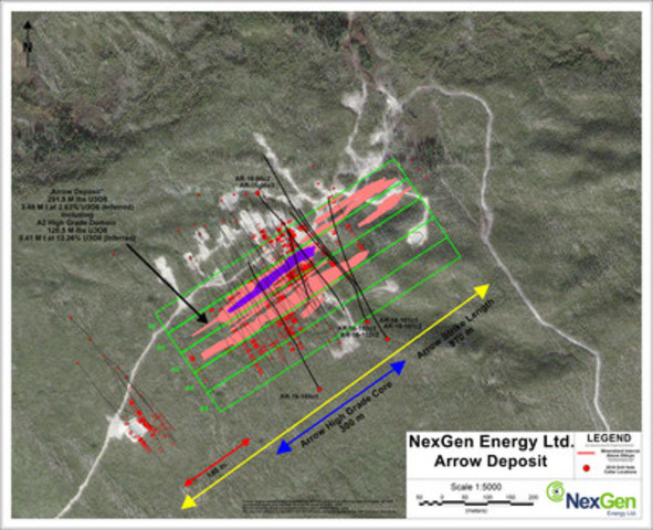
Figure 2: A2 Mineralized Shear Long Section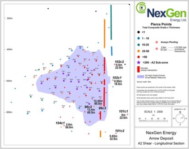
Figure 3: A3 Mineralized Shear Long Section