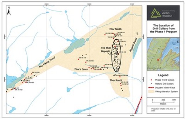
Anaconda Mining Inc. (TSX: ANX) ("Anaconda" or the "Company") is pleased to announce it has completed the first phase of exploration (the "Phase 1 Exploration Program") at its Viking Project ("Viking") located on the Northern Peninsula near Sop's Arm, Newfoundland. The Phase 1 Exploration Program was focused on three general target areas: the north and south strike extensions of the Thor Deposit, Thor's Cross and the Viking Trend, with the primary goal of demonstrating the potential to significantly grow the resource base at the Viking Project (Exhibit A).
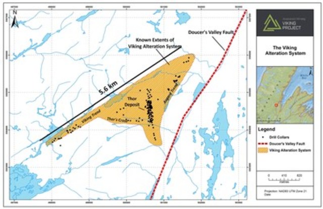
The program consisted of a review of previously drilled core and geochemical characterization of the Thor Deposit, geological mapping, 4,136 metres of diamond drilling and the reprocessing of historic magnetic and ground IP geophysical data. Anaconda was successful in extending the strike length of the Thor Deposit and outlined broad zones of mineralization at the Viking Trend along with discovering new mineralization at Thor's Cross. The Viking Trend and Thor's Cross also contained localized high grade intersections (Exhibit B). Highlights of the Phase 1 Exploration Program include:
- Gold bearing alteration zones intersected in 21 of 27 drill holes illustrating a widespread mineralizing system present at Viking;
- Extending the Thor Deposit 100 metres north along strike, for a total of 650 metres of strike length, at shallow depths, as demonstrated by 2.73 grams per tonne ("g/t") gold over 6.0 metres in hole VK-16-30, 1.25 g/t gold over 7.0 metres in hole VK-16-31, and 1.16 g/t gold over 4.0 metres in hole VK-16-132;
- Intersecting a 40 to 80-metre wide zone of very intense alteration and broad zones of gold mineralization that characterize the Viking Trend as exemplified by 0.45 g/t gold over 20 metres in hole VK-16-151 and 0.37 g/t gold over 16.5 metres in an historic drill hole, VK-11-125 as well as local high grades as indicated by 7.43 g/t gold over 1.0 metre in hole VK-16-155;
- Determining that Thor's Cross is an area at least 100 metres in strike length, characterized by a 20-metre wide zone of alteration and gold mineralization coincident with a fault structure as demonstrated by 0.78 g/t gold over 10.3 metres in hole VK-16-144, 0.42 g/t gold over 8.0 metres in hole VK-16-141 and 0.45 g/t gold over 7.9 metres in hole VK-16-143 as well as local high grades as indicated by 9.93 g/t gold over 0.3 metres in hole VK-16-148;
- Fingerprinting of the key geochemical, geophysical and structural characteristics of the Thor Deposit and developing new, refined drill targets based on the fingerprint characteristics. Follow-up drilling will focus on new targets at the Viking Trend and south of the Thor Deposit as well as at the Asgard/Kramer Trend where significant gold mineralization is associated with a quartz veining and the quartzite unit exemplified by historic drill holes - 1.12 g/t gold over 20 metres in hole KR-10-07 and 1.50 g/t gold over 14.0 metres in hole KR-10-07.
Anaconda's diamond drill results confirm a widespread mineralized system exists throughout the areas of the Viking Project that have been tested by the Company. There are broad zones of lower-grade mineralization along with narrow zones of higher grade mineralization. In addition, historic drill results reaffirm this notion in similar areas and areas that have not yet been drilled by Anaconda. It's significant because it demonstrates that the gold mineralization process is occurring over a wide area, which raises the potential of finding additional mineral resources. The tables below contain certain current and historic diamond drill results from selected areas that illustrate the occurrence of varying gold tenor over a large area.
The Viking Trend
| Hole ID | From(m) | To(m) | Interval (m) |
Au(g/t) | Age of Core |
| VK-16-154 | 48.0 | 68.0 | 20.0 | 0.45 | Current |
| VK-16-155 | 36.0 | 37.0 | 1.0 | 7.43 | Current |
| VK-11-125 | 12.5 | 29.0 | 16.5 | 0.37 | Historic |
| VK-10-88 | 2.6 | 29.3 | 26.7 | 0.29 | Historic |
| SM-89-01 | 30.1 | 35.4 | 5.3 | 0.56 | Historic |
The Asgard/Kramer Trend
| Hole ID | From(m) | To(m) | Interval (m) |
Au(g/t) | Age of Core |
| KR-13-17 | 19.2 | 20.2 | 1.0 | 13.21 | Historic |
| KR-10-07 | 53.5 | 73.6 | 20.1 | 1.12 | Historic |
| KR-10-08 | 66.9 | 81.3 | 14.4 | 1.50 | Historic |
| KR-10-14 | 27.8 | 39.5 | 11.7 | 1.04 | Historic |
President and CEO, Dustin Angelo, states, "Through our exploration program and incorporating previous work, we have outlined a broad area of alteration and gold mineralization associated with structures adjacent to the Doucer's Valley Fault, which is almost six kilometres long. These features are a key indicator for the presence of large orogenic gold deposits. We are focused on finding the sweet spots, like the Thor Deposit, within this broad gold-bearing system. Recent data collection has led to fingerprinting of the key geochemical, geophysical and structural characteristics of the Thor Deposit. Armed with these characteristics, the second phase of drilling will test more specific targets along the Thor Deposit and Viking Trends."
The Viking Project is located along the Doucer's Valley Fault, part of the Long Range fault system, which is a significant geological control on as many as nine gold deposits, which collectively include millions of ounces of gold. The Doucer's Valley Fault is considered integral in the formation of gold deposits including Anaconda's Thor Deposit (83,000 ounces Indicated and 31,000 ounces Inferred Resources*) and the Rattling Brook Deposit (495,000 ounces Inferred Resources**) hosted within the same rocks adjacent to the Doucer's Valley Fault and approximately 20 kilometres from one another. The regional geological setting along with the known deposits and specific exploration results at Viking suggest the potential to delineate additional mineral resources throughout the project area.
A table summarizing the composited drill results of the Phase 1 Exploration Program at Viking is shown below.
Thor North
| Hole ID | From (m) | To (m) | Interval (m) | Au (g/t) |
| VK-16-129 | 93.0 | 96.0 | 3.0 | 0.55 |
| and | 101.0 | 102.0 | 1.0 | 0.64 |
| VK-16-130 | 14.4 | 20.4 | 6.0 | 2.73 |
| including | 17.4 | 20.4 | 3.0 | 4.97 |
| VK-16-130 | 37.0 | 38.0 | 1.0 | 1.01 |
| and | 44.0 | 46.0 | 2.0 | 1.03 |
| and | 117.4 | 117.8 | 0.4 | 0.54 |
| and | 130.5 | 131.0 | 0.5 | 0.80 |
| and | 135.2 | 135.8 | 0.6 | 0.97 |
| VK-16-131 | 10.1 | 17.1 | 7.0 | 1.25 |
| including | 14.1 | 17.1 | 3.0 | 2.45 |
| and | 76.0 | 77.0 | 1.0 | 0.59 |
| VK-16-132 | 25.0 | 29.0 | 4.0 | 1.16 |
| including | 25.0 | 26.0 | 1.0 | 3.47 |
| and | 35.0 | 36.0 | 1.0 | 1.07 |
| and | 110.8 | 113.8 | 3.0 | 0.68 |
| VK-16-133 | 121.5 | 122.2 | 0.7 | 1.50 |
| and | 150.0 | 151.0 | 1.0 | 0.60 |
| VK-16-134 | 62.0 | 63.0 | 1.0 | 0.53 |
| and | 85.0 | 86.0 | 1.0 | 0.57 |
| and | 151.4 | 153.0 | 1.6 | 0.86 |
| and | 186.8 | 188.0 | 1.2 | 0.69 |
| VK-16-135 | 26.0 | 27.0 | 1.0 | 0.80 |
| VK-16-136 | 11.0 | 12.0 | 1.0 | 0.54 |
| VK-16-137 | 22.0 | 24.0 | 2.0 | 0.81 |
| and | 72.5 | 74.5 | 2.0 | 0.57 |
| and | 108.0 | 110.0 | 2.0 | 0.70 |
| VK-16-137 | 183.0 | 184.0 | 1.0 | 0.51 |
| VK-16-138 | 62.0 | 63.0 | 1.0 | 0.92 |
Thor South
| Hole ID | From (m) | To (m) | Interval (m) | Au (g/t) |
| VK-16-139 | 18.2 | 19.2 | 1.0 | 0.69 |
| VK-16-140 | 24.0 | 25.0 | 1.0 | 0.58 |
| VK-16-141 | 52.0 | 60.0 | 8.0 | 0.42 |
| VK-16-142 | 31.1 | 33.1 | 2.0 | 0.93 |
Thor's Cross
| Hole ID | From (m) | To (m) | Interval (m) | Au (g/t) |
| VK-16-143 | 8.5 | 16.4 | 7.9 | 0.45 |
| and | 20.5 | 21.0 | 0.5 | 0.66 |
| VK-16-144 | 30.0 | 40.3 | 10.3 | 0.78 |
| including | 37.3 | 40.3 | 3.0 | 1.22 |
| and | 42.9 | 45.4 | 2.5 | 0.49 |
| and | 49.4 | 50.4 | 1.0 | 0.53 |
| and | 55.6 | 57.6 | 2.0 | 0.49 |
| VK-16-145 | 29.8 | 39.8 | 10.1 | 0.49 |
| and | 47.8 | 50.1 | 2.3 | 0.50 |
| and | 81.0 | 84.0 | 3.0 | 0.94 |
| VK-16-146 | 49.0 | 51.0 | 2.0 | 0.56 |
| and | 89.0 | 90.7 | 1.7 | 1.09 |
| and | 97.0 | 99.0 | 2.0 | 0.53 |
| VK-16-148 | 96.1 | 96.4 | 0.3 | 9.93 |
| VK-16-149 | 6.0 | 8.0 | 2.0 | 1.73 |
| and | 79.0 | 80.0 | 1.0 | 0.84 |
| and | 123.8 | 125.0 | 1.2 | 0.89 |
| and | 145.0 | 146.0 | 1.0 | 1.13 |
| and | 156.0 | 157.0 | 1.0 | 0.50 |
| and | 158.0 | 162.0 | 4.0 | 0.47 |
The Viking Trend
| Hole ID | From (m) | To (m) | Interval (m) | Au (g/t) |
| VK-16-150 | 34.0 | 38.0 | 4.0 | 0.47 |
| VK-16-151 | 28.0 | 28.9 | 0.9 | 0.62 |
| and | 30.0 | 32.0 | 2.0 | 0.85 |
| VK-16-151 | 89.0 | 92.0 | 3.0 | 0.51 |
| and | 94.8 | 96.0 | 1.2 | 0.50 |
| VK-16-152 | 75.0 | 78.0 | 3.0 | 0.60 |
| and | 91.0 | 92.0 | 1.0 | 0.67 |
| VK-16-153 | 27.5 | 28.5 | 1.0 | 0.53 |
| VK-16-154 | 48.0 | 68.0 | 20.0 | 0.45 |
| including | 49.0 | 50.7 | 1.7 | 2.42 |
| VK-16-155 | 8.0 | 9.0 | 1.0 | 0.61 |
| and | 36.0 | 37.0 | 1.0 | 7.43 |
| and | 45.0 | 46.0 | 1.0 | 0.65 |
*Resource taken from the NI 43-101 report for the Viking project entitled "NI 43-101 Technical Report and Mineral Resource Estimate on the Thor Deposit, Viking Project, White Bay Area, Newfoundland and Labrador, Canada" with an effective date of August 29, 2016" and using a cut off grade of 0.5 g/t.
**Resource taken from the NI 43-101 report for the Jackson's Arm Project entitled "TECHNICAL REPORT ON MINERAL RESOURCE ESTIMATE FOR JACKSON'S ARM GOLD PROJECT WHITE BAY AREA NEWFOUNDLAND AND LABRADOR, Latitude 49o 53' 2.65'' North, Longitude 56o 50' 7.09'' West", with an effective date of April 20th, 2009. Prepared For: Kermode Resources Ltd. by Mercator Geological Services Limited.
This news release has been reviewed and approved by Paul McNeill, P. Geo., VP Exploration with Anaconda Mining Inc., a "Qualified Person", under National Instrument 43-101 Standard for Disclosure for Mineral Projects.
All samples are collected using QA/QC protocols including the regular insertion of duplicates, standards and blanks within the sample batch for analysis. All samples quoted in this release were analyzed at Eastern Analytical Ltd. in Springdale, NL, for Au by fire assay (30g) with an AA finish.
Mineralized intervals are reported as drill intersections and are apparent widths only. Apparent widths reported in this press release are estimated to be approximately 80 – 100% of true widths.
ABOUT ANACONDA MINING
Anaconda Mining is a growth-oriented, gold mining and exploration company with a producing project called the Point Rousse Project and two exploration/development projects called the Viking and Great Northern Projects in Newfoundland.
The Point Rousse Project is approximately 6,300 hectares of property on the Ming's Bight Peninsula located in the Baie Verte Mining District in Newfoundland, Canada. Since 2012, Anaconda has increased its property control by ten-fold on the peninsula and gold production to nearly 16,000 ounces per year. In an effort to expand production, it is currently exploring three primary, prospective gold trends, which have approximately 20 km of cumulative strike length and include five deposits and numerous prospects and showings, all within 8 km of the Pine Cove Mill. A second property called the Tilt Cove Property, consisting of 350 hectares, is located approximately 60 kilometres by road from the Pine Cove Mill but is also within the Baie Verte Mining District and underlain by similar geology to the Point Rousse Project.
Anaconda also controls the Viking and Great Northern Projects, which have approximately 6,225 and 6,375 hectares of property (respectively) in White Bay, Newfoundland, approximately 100 kilometres by water (180 kilometres via road) from the Pine Cove Mill. The Viking Project contains the Thor Deposit and other gold prospects and showings and the Great Northern Project includes numerous prospects and showings within a similar geological setting as the Viking Project. The Company's plan is to discover and develop more resources within these project areas and substantially increase annual production at the Pine Cove Mill from its current rate of nearly 16,000 ounces.
As the only pure play gold producer in Atlantic Canada, Anaconda Mining is turning the rock we live on into a growing and profitable resource. With a young and motivated workforce, innovative technology and the support of local suppliers, Anaconda is investing in the people of Newfoundland & Labrador and giving back to the communities in which we operate – building a better future for all our stakeholders, from the ground up.
Source: Anaconda Mining