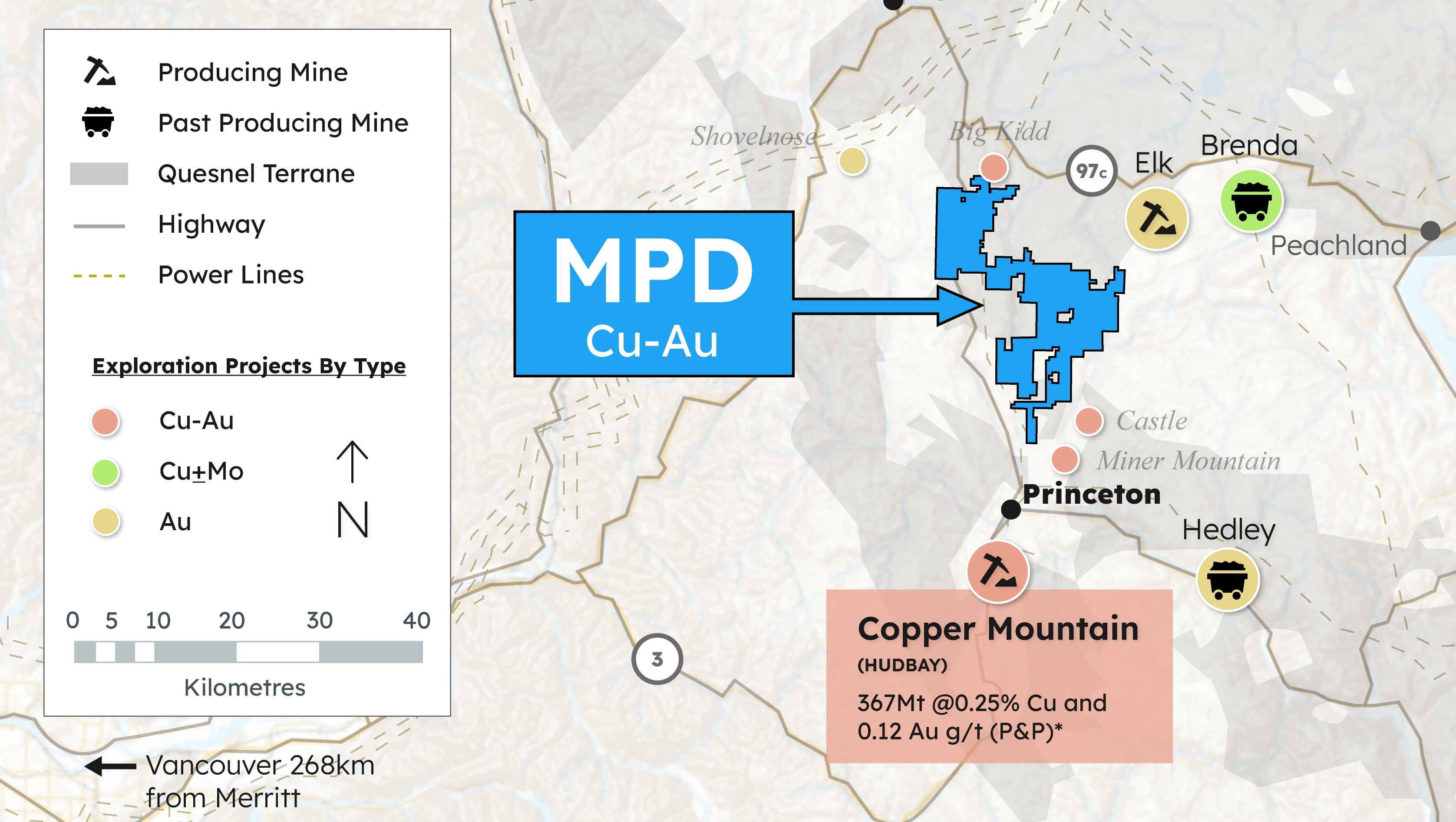
Edmonton, Alberta--(Newsfile Corp. - May 22, 2025) - Sankamap Metals Inc. (CSE: SCU) ("Sankamap" or the "Company") is pleased to provide historical exploration results from the Oceania Project's 4,500-hectare ("Ha") Kuma property ("Kuma"), located in Guadalcanal, Solomon Islands. The Kuma property is situated 37 kilometers ("km") southeast of Honiara, the capital city of Guadalcanal. Historical exploration at Kuma has identified large-scale copper-gold ("Cu-Au") mineralization and promising indicators of a potential porphyry deposit, which remains untested by drilling (see regional location in our May 7, 2025 press release).
CEO John Florek commented "We are enthusiastic about the discovery potential at the Kuma property, where historical exploration has outlined a kilometer-scale Cu-Au anomaly, including surface samples grading up to 13.5 g/t gold and 11.7% copper3; remarkably, this area remains untested by drilling. The Kuma property presents an exceptional exploration opportunity, located along a highly prospective copper-gold trend that hosts several major deposits, including Lihir1 and Panguna6. By building on previous work, we aim to further refine our porphyry target, strengthening the foundation for our upcoming drill program and creating long-term value for our shareholders."
Exploration Highlights
- Rock chip sampling on the Kuma property returned assays of up to 13.5 g/t gold and 11.7% copper.
- Kilometer-scale Cu-Au anomalies were delineated through rock and soil geochemical assays.
- Hydrothermal alteration mapping delineated a lithocap extending over 2 kilometers, characterized by distinct zones of phyllic, advanced argillic, and argillic alteration
Initial exploration at the Kuma property began in the 1990s, with the identification of massive oxidized boulders, which were subsequently traced upstream to Alemba Creek in 2007 (Figure 1), leading to the delineation of the Kuma prospect. Between 2007 and 2019, exploration efforts included soil and rock geochemical sampling, geological and alteration mapping, and airborne geophysical surveys. Hyperspectral analysis defined a >2 km lithocap with well-developed phyllic, argillic, and advanced argillic alteration assemblages, indicative of a high-sulphidation epithermal to porphyry-style system. Geochemical data revealed kilometer-scale anomalies in both gold and copper within the lithocap, highlighting significant, untested mineral potential.
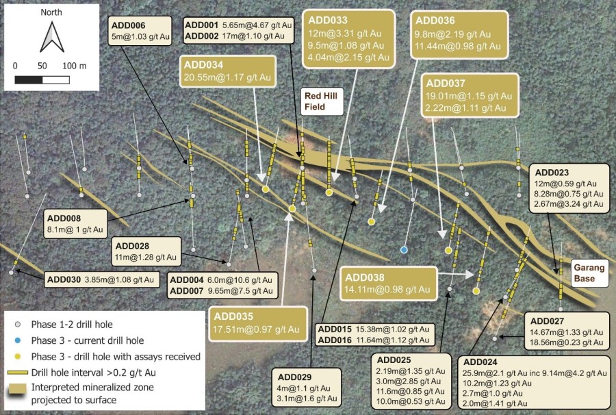
Historical Samples collected on the Kuma property summarized in a table below:
| Rock Samples | ~698 rock samples collected | 13 samples >0.5 g/t Au, including sample of 11.7% Cu and 13.5 g/t Au |
| 26 samples > 500 ppm Cu, including 7 samples > 1000 ppm Cu | ||
| Soil Samples | ~168 soil samples collected | 13 samples >200ppm Cu, including 1 sample >500 ppm Cu |
| 112 samples >40 ppb Au including 4 samples >100 ppb Au | ||
| Steam Sediment Samples | ~88 stream sediment samples collected | Up to 15 ppb Au |
Table reference: Historical grab, soil and BLEG samples from SolGold Kuma Review June 2015, and SolGold plc Annual Report 2013/ 2012
 Figure 1: Large, altered boulders present on the Kuma Property
From 2007 to 2009, Australian Resource Management conducted reconnaissance-scale rock float and stream sediment sampling along the Tabala Ridge, an area characterized by northwest-trending, structurally controlled lineaments interpreted as parallel fault zones. Initial evidence of a porphyry-style system was identified through the occurrence of hypogene copper sulphides, chalcopyrite and bornite, locally overprinted by weak supergene enrichment, indicative of a zoned hydrothermal system (Figure 1).
 Figure 2: Kuma Lithocap footprint in comparison to select porphyry deposits
Panguna: 1.5 Mt containing 16.1 Moz Au at 0.33 g/t and 4.6 Mt Cu at 0.3 % Indicated, 300 Mt containing 3.2 Moz Au 0.4 g/t and 0.7 Mt Cu Inferred
Between 2010 and 2013, Newmont Exploration (NVL-SI) conducted a comprehensive program at the Kuma property, including rock sampling, Bulk Leach Extractable Gold (BLEG) sampling, geological mapping, airborne magnetic and electromagnetic survey, and hyperspectral analysis of rock samples. This work delineated a ~2 km lithocap characterized by discrete zones of advanced argillic, argillic, and silicic alteration.
Lithocaps represent the upper, hydrothermally altered portions of porphyry systems and are typically defined by extensive, near-surface alteration footprints. The lithocap identified at Kuma exhibits alteration assemblages consistent with high-sulphidation epithermal environments, suggesting proximity to a potential porphyry center at depth. The spatial scale and mineralogical zonation of the alteration system (Figures 2 & 3) support the presence of a large, concealed porphyry Cu-Au system beneath the current surface exposure.
From 2014 to 2019, SolGold carried out comprehensive geological mapping, a systematic soil sampling program, and hyperspectral analysis of the soil samples. The hyperspectral data provided a more refined alteration map, highlighting distinct zones of phyllic, argillic, and advanced argillic alteration. Notably, alteration minerals such as dickite and pyrophyllite were identified, which are common surficial indicators of underlying porphyry systems at depth (Figure 3).
Summary
Integrated data define a vertically zoned hydrothermal system consistent with a telescoped porphyry model: a phyllic core (quartz-sericite-pyrite) surrounded by argillic and advanced argillic assemblages (kaolinite, alunite, dickite). The alteration footprint lies within a lithocap interpreted as the upper expression of a concealed porphyry system.
Regionally, Kuma lies within a fertile Cu-Au corridor hosting major deposits like Lihir and Panguna.
These results highlight the potential for a concealed porphyry center beneath the lithocap, warranting follow-up geophysical surveys and targeted drilling.
 Figure 3: Kuma property Cu-Au anomalies with mapped alteration and structures
Next Steps
Historical exploration at the Kuma property has outlined a compelling porphyry target based on surface geochemical sampling, geological mapping, and geophysical data; yet remains untested by drilling. A follow-up exploration program is scheduled to commence in mid-May 2025, as announced in our May 7, 2025, press release. The planned work includes a MobileMT geophysical survey, high-resolution airborne photogrammetry and LiDAR acquisition, and a targeted rock sampling campaign to refine drill targets and enhance geological understanding of the system.
The key goals of the upcoming exploration program are to:
- Advance the project's subsurface geological model through a MobileMT survey, aimed at detecting conductive and resistive trends indicative of porphyry and high-sulphidation epithermal mineralization systems.
- Improve surficial geological understanding of the property, including outcrop distribution, geomorphology, and structural features, through the generation of a high-resolution Digital Surface Model (DSM) and a high-accuracy Digital Terrain Model (DTM).
- Validate historical surface geochemical results and identify new target areas through a systematic rock sampling program led by the Sankamap exploration team.
- Enhance target definition by building a robust and geologically meaningful dataset to support the design and execution of the upcoming drill program.
This disciplined and data-driven approach leverages existing historical information to generate a comprehensive exploration dataset, improving target confidence and guiding drill planning with greater precision.
*Disclaimer: References to the Lihir and Panguna deposits are provided solely to illustrate the potential scale of mineralization that could exist in similar geological settings. These references are not intended to imply that mineralization of similar type, size, or grade is present on Sankamap's property. There has been insufficient exploration to define a mineral resource on Sankamap's property, and it is uncertain whether further exploration will result in the delineation of a mineral resource. Not all historical information including, but not limited to magnetic survey data, QAQC procedures, lab assay certificates for historical exploration and sampling is available to Sankamap metals, historical exploration was in quarterly, annual and press releases.
About Sankamap Metals Inc.
Sankamap Metals Inc. (CSE: SCU) is a Canadian mineral exploration company dedicated to the discovery and development of high-grade copper and gold deposits through its flagship Oceania Project, located in the South Pacific. The Company's fully permitted assets are strategically positioned in the Solomon Islands, along a prolific geological trend that hosts world-class copper-gold deposits; including Newcrest's Lihir Mine, with a resource of 71.9 million ounces of gold¹ (310 Mt containing 23 Moz Au at 2.3 g/t P+P, 520 Mt containing 39 Moz Au at 2.3 g/t indicated, 81 Mt containing 5 Moz Au at 1.9 g/t measured, 61 Mt containing 4.9 Moz Au at 2.3 g/t Inferred).
Exploration is actively advancing at both the Kuma and Fauro properties, part of Sankamap's Oceania Project in the Solomon Islands. Historical work has already highlighted the mineral potential of both sites, which lie along a highly prospective copper and gold-bearing trend, suggesting the possibility of further, yet-to-be-discovered deposits.
At Kuma, the property is believed to host an underexplored and largely untested porphyry copper-gold (Cu-Au) system. Historical rock chip sampling has returned consistently elevated gold values above 0.5 g/t Au, including a standout sample assaying 11.7% Cu and 13.5 g/t Au3; underscoring the area's significant potential.
At the Fauro property, particularly at the Meriguna target, historical trenching has revealed highly encouraging results, including 8.0 meters at 27.95 g/t Au and 14.0 meters at 8.94 g/t Au3, along with grab samples reaching up to 173 g/t Au3. Additionally, limited historical shallow drilling encountered 35.0 meters at 2.08 g/t Au3, further supporting the property's prospectivity.
With a commitment to systematic exploration and a team of experienced professionals, Sankamap aims to unlock the untapped potential of underexplored regions and create substantial value for its shareholders. For more information, please refer to SEDAR+ (www.sedarplus.ca), under Sankamap's profile.
1.Newcrest Technical Report, 2020 (Lihir: 310 Mt containing 23 Moz Au at 2.3 g/t P+P, 520 Mt containing 39 Moz Au at 2.3 g/t indicated, 81 Mt containing 5 Moz Au at 1.9 g/t measured, 61 Mt containing 4.9 Moz Au at 2.3 g/t Inferred)
2. Bougainville Copper Ltd. Annual Report, 2016 (1.5 Mt containing 16.1 Moz Au at 0.33 g/t and 4.6 Mt Cu at 0.3 % Indicated, 300 Mt containing 3.2 Moz Au 0.4 g/t and 0.7 Mt Cu Inferred)
3. Historical grab, soil and BLEG samples from SolGold Kuma Review June 2015, and SolGold plc Annual Report 2013/2012
4. PT Amman Mineral Internasional Tbk Annual Report, 2023 - Batu Hijau (Reserves of 759 Mt containing 6.2 Blbs Cu at 0.37 % and 7.5 Moz Au at 0.31 g/t, resources of 1,675 Mt containing 9.1 Blbs Cu at 0.25 % and 5.9 Moz Au at 0.11 g/t Au. Produced 9.7 Blbs Cu and 10 Moz Au, as or December 31, 2023) Elang (Reserves of 1,415 Mt containing 10.4 Blbs Cu at 0.33 % Cu, and 15.0 Moz Au at 0.33 g/t Au, resources of 2,282 Mt containing at 14.15 Blbs Cu at 0.28 % and 19.4 Moz Au at 0.26 g/t Au)
5. Maryono, A., Harrison, R.L., Cooke, D.R., Rompo, I.R., Hoschke, T.G., 2018, Tectonics and geology of porphyry Cu-Au deposits along the eastern Sunda magmatic arc, Indonesia, Economic Geology, v. 113, pp. 7-38.
6. Eastoe, C.J., 1979, The formation of the Panguna porphyry copper deposit, Bougainville, Papua New Guinea, unpub. PhD. thesis, University of Tasmania, Hobart (Panguna: 1.5 Mt containing 16.1 Moz Au at 0.33 g/t and 4.6 Mt Cu at 0.3 % Indicated, 300 Mt containing 3.2 Moz Au 0.4 g/t and 0.7 Mt Cu Inferred)
QP Disclosure
The technical content for the Oceania Project in this news release has been reviewed and approved by John Florek, M.Sc., P.Geol., a Qualified Person in accordance with CIM guidelines. Mr. John Florek is in good standing with the Professional Geoscientists of Ontario (Member ID:1228) and an officer of the Company.
ON BEHALF OF THE BOARD OF DIRECTORS
s/ "John Florek"
John Florek, M.Sc., P.Geol
Chief Executive Officer
Sankamap Metals Inc.
Contact:
John Florek, CEO
T: (807) 228-3531
E: This email address is being protected from spambots. You need JavaScript enabled to view it.
The Canadian Securities Exchange has not approved nor disapproved this press release.
Forward-Looking Statements
This news release includes certain forward-looking statements, including with respect to the timing from which the common shares will trade on the CSE under the new name of the Company and management's objectives, strategies, beliefs and intentions. Forward looking statements are frequently identified by such words as "may", "will", "plan", "expect", "anticipate", "estimate", "intend" and similar words referring to future events and results. Forward-looking statements are based on the current opinions and expectations of management. All forward-looking information is inherently uncertain and subject to a variety of assumptions, risks and uncertainties, as described in more detail in the Company's securities filings available at www.sedarplus.ca. Actual events or results may differ materially from those projected in the forward-looking statements and we caution against placing undue reliance thereon. We assume no obligation to revise or update these forward-looking statements except as required by applicable law.