Vancouver, British Columbia--(Newsfile Corp. - July 23, 2025) - Route 109 Resources Inc. (TSXV: RTE) (OTCQB: MRIRF) (FSE: 8M0) ("Route109" or the "Company") announces results from its 2025 winter drilling program on Dunlop Bay property confirming the presence of a Au-Cu-Mo porphyry-style mineralized system related with the Dunlop Bay intrusion. The 2025 winter program included two drillholes designed to test the eastern tip of the Dunlop Bay Intrusion (see drillhole BD-25-31 and BD-25-32 on Figure 1). Those drillholes intersected intrusive rocks that returned anomalous Au-Cu-Mo results. A similar base metals package that was found and assay results were released previously released for Dunlop Bay West (see May 29, 2025 Route109 Press Release). The information obtained from these drill holes (Table 1) coupled with historical information (Table 2, GM 48615 and GM 44938) allow the company to conclude that a part of the mineralization found on the Dunlop Bay property is related to a porphyry-style system which is atypical of the Matagami region.
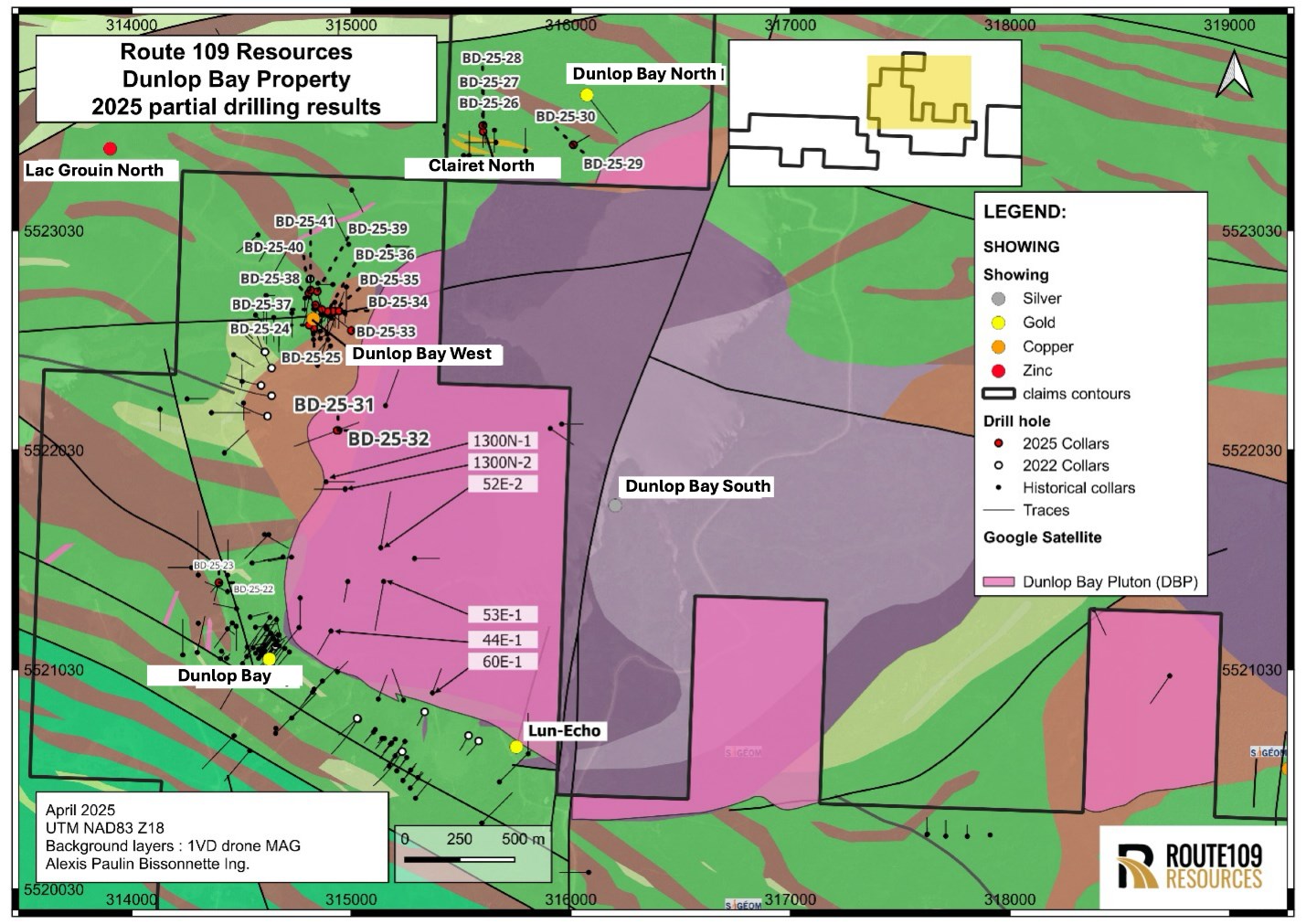 Figure 1: 2025 Dunlop Bay property drilling program planned collars.
Results presented in Table 1, compared with previously released information from Dunlop Bay North, Clairet and Dunlop Bay West (see May 29, 2025 Route109 Press Release), show two different styles of mineralization. Dunlop Bay West, located near the intrusion contact and drillholes 31 and 32, located within the Dunlop Bay intrusion, both reveal enrichment in Mo-Cu-Au when compared to the Clairet and Dunlop Bay North areas, located more distally from the intrusion and hosting a much more classical VMS-related base metal enrichment.
Robert Pryde, CEO of the company said: "We are quite excited by the evidence of porphyry-style mineralization within the Dunlop Bay property. Over a three-year period, RTE has been actively exploring for high-grade gold and silver within the Abitibi Greenstone belt complexes in the Matagami region. These results show the exploration potential of the property which needs to be followed up with additional geophysics and drilling targeting the porphyry system."
| DDH | From | To | Length | Au (g/t) | Ag (g/t) | Cu (ppm) | Mo (ppm) | Pb (ppm) | Zn (ppm) |
| BD-25-31 | 18.5 | 19 | 0.5 | 7.05 | 11.6 | 569 | 5 | 17 | 88 |
| 34 | 34.5 | 0.5 | 0.024 | 0.25 | 157 | 136 | 7 | 80 | |
| 50 | 50.5 | 0.5 | 0.291 | 0.25 | 136 | 7 | 4 | 96 | |
| 52 | 52.5 | 0.5 | 0.048 | 0.25 | 206 | 1620 | 3 | 103 | |
| 57.5 | 58 | 0.5 | 0.391 | 0.7 | 173 | 9 | 3 | 100 | |
| 72.9 | 73.4 | 0.5 | 0.152 | 0.25 | 1130 | 6 | 2 | 92 | |
| 72.9 | 73.4 | 0.5 | 0.152 | 0.25 | 1130 | 6 | 2 | 92 | |
| 192 | 192.5 | 0.5 | 0.136 | 0.25 | 389 | 23 | 4 | 71 | |
| BD-25-32 | 41.8 | 43 | 1.2 | 0.126 | 0.25 | 34 | 1 | 7 | 32 |
| 49.2 | 51.7 | 2.5 | 0.427 | 1.47 | 95.32 | 11.12 | 0 | 24.6 | |
| 58.5 | 60 | 1.5 | 0.219 | 0.25 | 55 | 2 | 3 | 27 | |
| 63 | 63.7 | 0.7 | 0.344 | 0.25 | 12 | 2 | 2 | 25 | |
| 73.5 | 74.1 | 0.6 | 0.706 | 1.3 | 67 | 5 | 10 | 42 | |
| 98.4 | 99.3 | 0.9 | 0.11 | 0.5 | 420 | 3 | 5 | 56 | |
| 104.6 | 108.45 | 3.85 | 0.242 | 2.38 | 1283.97 | 12.86 | 0 | 36.52 | |
| 133.5 | 134.1 | 0.6 | 0.205 | 1.7 | 11 | 2 | 7 | 39 |
Table 1: Best results from drillholes BD-25-31 and BD-25-32 located within the Dunlop Bay intrusion.
As displayed in Figure 1 and Table 1, several gold intersections were encountered in the Dunlop Bay Intrusion by historical drilling. This winter program further validates the presence of gold in the intrusion as well as demonstrates the presence of Cu and Mo in association with the gold.
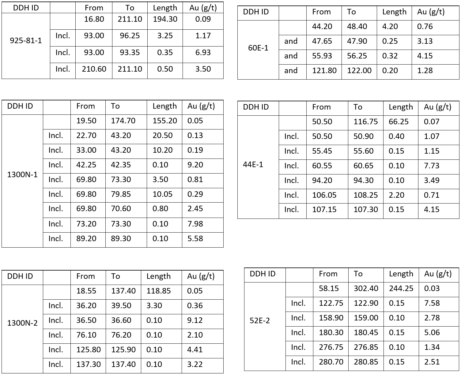 Table 2: Highlights from historical drilling located within the Dunlop Bay intrusion (source: GM 48615 and GM 44938).
As shown in Table 2 and Figure 2, both drill holes returned several gold showings (going up to 7.05 ppm Au, 11.60 ppm Ag, 569 ppm Cu over 0.5 meter in drillhole BD-25-31), copper (0.13% Cu over 3.85 meters in drillhole BD-25-32), and molybdenum (going up to 1620 ppm Mo over 0.50 meter in drillhole BD-25-31). Note that drillhole BD-25-31, drilled westward, intersected a diorite intrusive body (low content of potassic felspar, see Figure 3A) while BD-25-32, drilled eastward, intersected a syenite intrusive body (up to 85% feldspar, mostly potassic, see Figure 3B). Due to overburden thickness a 38-meter untested gap, which hosts the contact between the two intrusive units, as of yet remains unexplored.
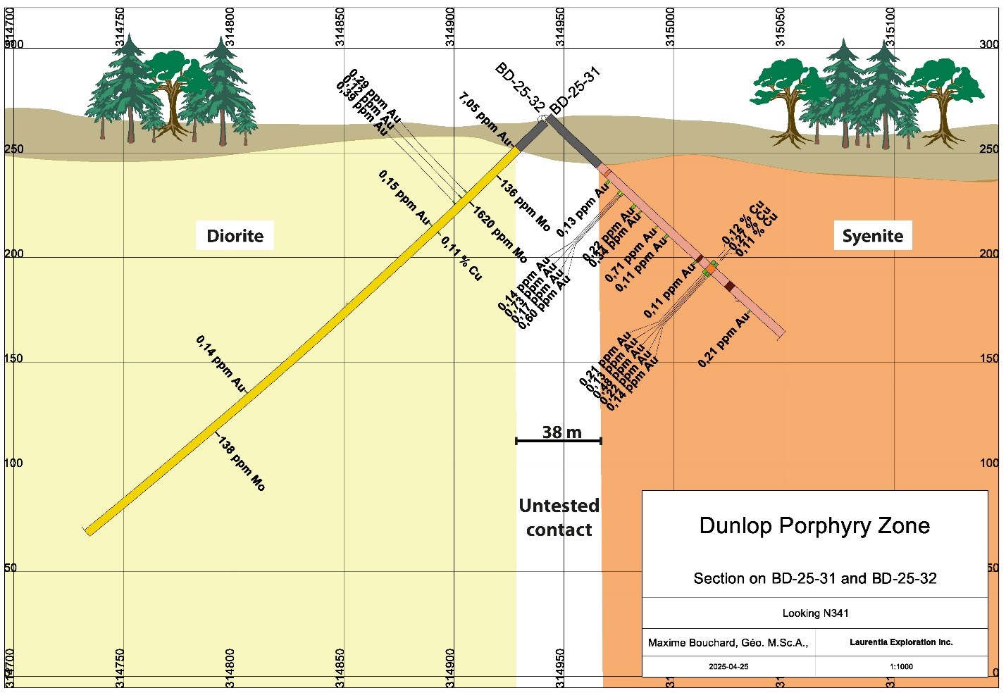 Figure 2: Cross section looking at N341 showing drill hole BD-25-31 and BD-25-32 geology and assay.
Core photos presented in Figure 3B, show the syenite as mainly massive, medium to coarse grained and hosts several intervals containing veinlets, sericite-albite-silicification and/or hematisation alterations. The diorite presented in Figure 3A is described as massive, medium to coarse grained and with a weak to moderate epidote, calcite and local potassic alterations. For both drillholes, intervals returning gold, copper, and molybdenum are correlating with observed veinlets and alterations.
This type of mineralization is not common to the immediate Matagami area, the best example in Archean rocks is the Cu-Au-Mo system in the Chibougamau area, in the NZV of the Abitibi belt, Québec (Labbé et al., 2006).
The characteristics of these porphyry deposits include:
1) networks of veinlets and fractures mineralized with pyrite + chalcopyrite + Mo,
2) massive sulfide lodes of kilometric extent bordered by chlorite and sericite alteration,
3) different generations of hydrothermal breccia, and
4) "inter-mineralization" dykes (Pilote et al., 1998).
It is noteworthy that mineralization in the Dunlop block is interpreted to be genetically related to a porphyry system (Dunlop West, Pluton and the NW2 2023 trenches) and shares similar characteristics to the "Chibougamau" type, Porphyry such as: massive sulfide lodes, veins, breccia-hosted sulfides and sulfide disseminations.
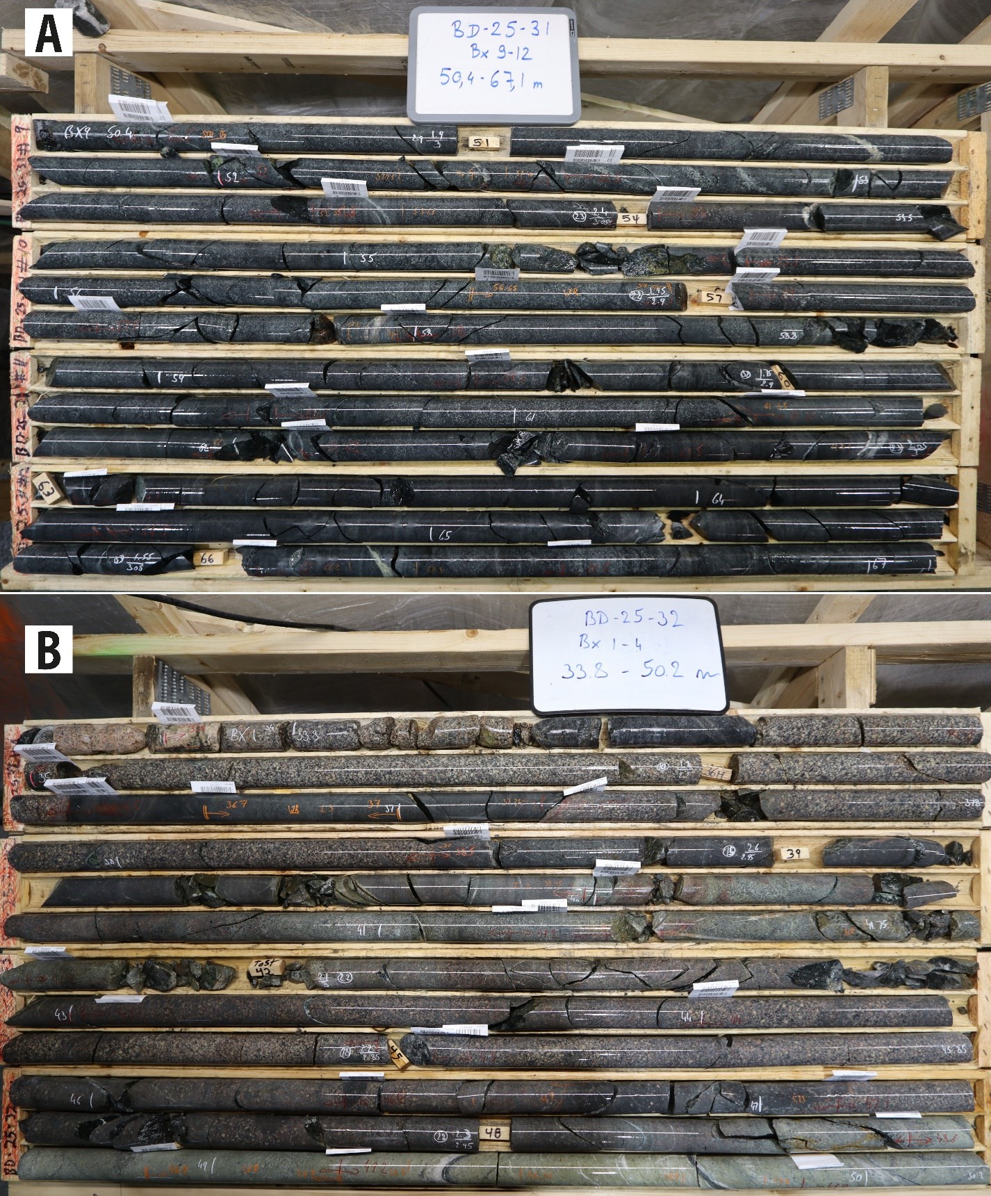 Figure 3: A) Dioritic rock from BD-25-31; B) Syenitic rock from BD-25-32.
It is interpreted that mineralization of the Dunlop West, Pluton and the NW2 2023 trenches are genetically related to the same porphyry system:
1) Porphyry types are commonly huge mineralized systems as exemplified by the Chibougamau area.
2) All the showings are aligned along a >2km long N-S trend, coincident with a N-S high mag trend (Figure 4). This trend is mostly untested by drilling.
3) The Dunlop Bay showing can also be included in the N-S trend (Figure 4), where mineralized loads are NW trending, whereas the Marcelle vein also curves to an N-S strike westward.
4) Finally, because the pluton is late tectonic, mineralization was fed from below. Consequently, the showings are interpreted to be the upper part exposures of a more developed and continuous mineralization at depth.
This new interpretation of the N-S trending mineralizing system opens up the exploration potential along an N-S trend over a 2km long strike length".
Laurentia Exploration of Saguenay Quebec was responsible for the drilling program, core logging and sample selection for geochemical sampling and assay.
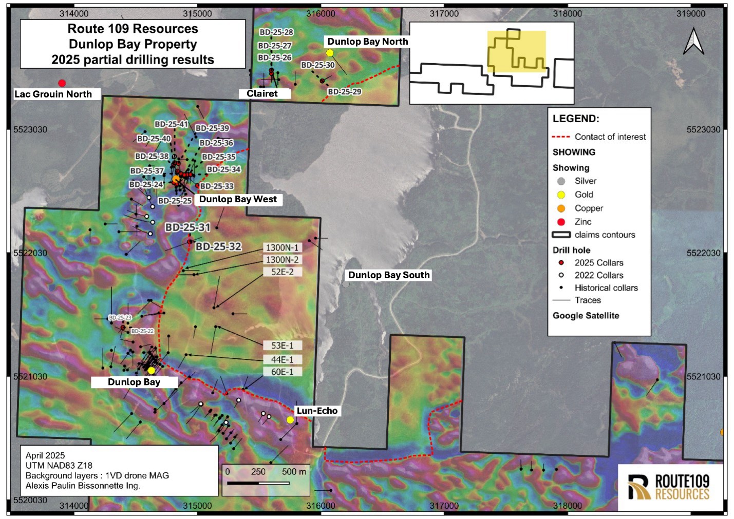 Figure 4 - Dunlop Bay Property 2025 Drilling Results Prospective Porphyry outline in Red
Qualified Person
Maxime Bouchard, Geo, M.Sc. (OGQ #1752), an independent Qualified Person as defined by Canadian NI 43-101 standards, has reviewed, and approved the geological information reported in this news release. The exploration and soil program were planned and supervised by Maxime Bouchard. The Qualified Person has not completed sufficient work to verify the historical information on the Property, particularly regarding historical drill results. However, the Qualified Person believes that drilling and analytical results were completed to industry standard practices. The information provides an indication of the exploration potential of the Property but may not be representative of expected results.
About Route 109 Resources Inc.
Route 109 Resources Inc. is a junior Canadian mining exploration company with the primary objective to acquire, explore, and develop viable gold and base metal projects in the mining-friendly jurisdiction of Quebec, Canada. Route109 is currently fully focused on its 100% interest in the two projects, both located in the prolific Abitibi greenstone belt:
- King Tut Project consists of 120 contiguous claims on 5,206 hectares
- Dunlop Bay Project consists of 76 mineral claims that cover 4,226 hectares
Route109 common shares trade under the symbol "RTE" on the TSX-V and under the symbol 8M0 on the Frankfurt Exchange.
For further information please contact:
Route 109 Resources Inc.
Robert Pryde, President
Tel: +1 (403) 478 6042
Email: This email address is being protected from spambots. You need JavaScript enabled to view it.
Neither the TSX Venture Exchange nor its Regulation Services Provider (as that term is defined in the policies of the TSX Venture Exchange) accepts responsibility for the adequacy or accuracy of this release. No stock exchange, securities commission or other regulatory authority has approved or disapproved the information contained herein.
This news release contains "forward-looking statements" and "forward-looking information" (as defined under applicable securities laws), based on management's best estimates, assumptions, and current expectations. Such statements include but are not limited to, statements with respect to the plans for future exploration and development of the King Tut and Dunlop Bay properties and the acquisition of additional exploration projects. Generally, these forward-looking statements can be identified by the use of forward-looking terminology such as "expects", "expected", "budgeted", "forecasts" , "anticipates" "plans", "anticipates", "believes", "intends", "estimates", "projects", "aims", "potential", "goal", "objective", "prospective", and similar expressions, or that events or conditions "will", "would", "may", "can", "could" or "should" occur. These statements should not be read as guarantees of future performance or results. Such statements involve known and unknown risks, uncertainties and other factors that may cause actual results, performance or achievements to be materially different from those expressed or implied by such statements, including but not limited to: risks related to the King Tut and Dunlop Bay projects; risks related to general economic conditions, actual results of current exploration activities, unanticipated reclamation expenses; changes in project parameters as plans continue to be refined; fluctuations in prices of metals including gold; increases in market prices of mining consumables, possible variations in resource estimates, grade or recovery rates; failure of plant, equipment or processes to operate as anticipated; accidents, labour disputes, title disputes, claims and limitations on insurance coverage and other risks of the mining industry; delays in the completion of exploration, development or construction activities, changes in national and local government regulation of mining operations, tax rules and regulations, and political and economic developments in areas in which the Company operates. Although the Company has attempted to identify important factors that could cause actual results to differ materially from those contained in forward-looking statements, there may be other factors that cause results not to be as anticipated, estimated or intended. There can be no assurance that such statements will prove to be accurate, as actual results and future events could differ materially from those anticipated in such statements. The forward-looking statements and forward-looking information are made as of the date hereof and are qualified in their entirety by this cautionary statement. The Company disclaims any obligation to revise or update any such factors or to publicly announce the result of any revisions to any forward-looking statements or forward-looking information contained herein to reflect future results, events or developments, except as require by law. Accordingly, readers should not place undue reliance on forward-looking statements and information. Please refer to the Company's most recent filings under its profile at www.sedarplus.ca for further information respecting the risks affecting the Company and its business.
References:
LABBÉ, J.-Y. - PILOTE, P. - LAMOTHE, D. 2006 - Évaluation du potentiel minéral pour les gîtes porphyriques de Cu-Au-Mo de l'Abitibi. Ressources naturelles et Faune, Québec, EP 2006-03. 46 p.
PILOTE, P. - ROBERT, F. - KIRKHAM, R.V. - DAIGNEAULT, R. - SINCLAIR, W.D., 1998 - Minéralisations de type porphyrique et filoniennes dans le Complexe du lac Doré - les secteurs du lac Clark et de l'île Merrill. Dans : Géologie et métallogénie du district minier de Chapais-Chibougamau; éditeur : P. Pilote. Ministère des Ressources naturelles, Québec; DV 98-03, page 71-90.