Bulk open pit potential emerging at Icon / Apollo Trend
HIGHLIGHTS:
- New step-out holes drilled at Icon targeting a large gap under previous drilling returned thick, high-grade gold, confirming mineralisation continuity and significant potential for resource growth. All holes ending in mineralisation, significant intercepts include:
- 154m at 1.1g/t gold from 76m including 5m at 22g/t gold (25GLR_062)
- 134m at 1g/t gold from 66m including 44m at 2.2g/t gold (25GLR_060)
- 117m at 0.7g/t gold from 107m including 38m at 1.1g/t gold (25GLR_064)
- In addition, the drilling at Icon delivered multiple gold intercepts exceeding 200m, all ending in mineralisation, including:
- 206m at 0.5g/t gold from 194m including 19m at 0.9g/t gold and 43m at 0.9g/t gold (25GLR_036)
- 272m at 0.5g/t gold from 157m including 41m at 1.6g/t gold (25GLR_032)
- 306m at 0.4g/t gold from 222m including 39m at 1.3g/t gold and 10m at 2.8g/t gold (25GLR_034)
- Geological modelling indicates that these zones remain open at depth, with strong potential for further extensions. Mineralisation is interpreted to link with the nearby Tuxedo deposit in a synformal geometry, outlining a potential 400 m wide mineralised envelope. This envelope comprises up to three broad higher-grade zones (100m wide, grading 0.8-1.5g/t gold), interconnected by a continuous lower-grade halo averaging 0.2-0.3g/t gold.
- Drilling to continue with two RC drill rigs fully funded by recent A$13.5M raising
Vancouver, British Columbia--(Newsfile Corp. - August 3, 2025) - Benz Mining Corp (ASX: BNZ) (TSXV: BZ) ("Benz" or the "Company") is pleased to report further strong results from ongoing drilling at the Icon Prospect within the Glenburgh Gold Project in Western Australia. Icon is located approximately 6km from the recently announced Zone 126 high grade trend and forms part of 18km of known gold trend at the Glenburgh Gold Project.
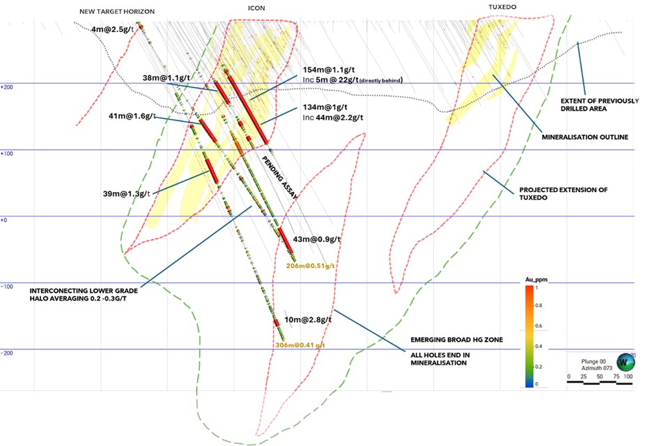 Figure 1. Section view looking north east at Icon Deposit, viewing window +/- 200m from section line.
The latest results have successfully confirmed the following major developments:
-
Mineralisation significantly exceeds previous defined boundaries with all intersections targeting deeper zones ending in mineralisation.
-
Zones of mineralisation appear to be linking up with the nearby Tuxedo deposit, suggesting that the system may grow to approximately 400m in width.
-
3 distinct higher grade 0.8 - 1.5g/t gold lenses emerging within this 400m package (see Figure 1).
-
A new zone potentially emerging to the north with a shallow hit of 4m at 2.5g/t gold.
Benz CEO, Mark Lynch-Staunton, commented: "The latest results from Icon are extraordinary. Intercepts of over 200 metres of mineralisation, all ending in gold, are the kind of outcome that would turn heads in any global gold district. These are the widths that porphyry explorers spend years chasing, and we're seeing them in a structurally controlled system with strong grade continuity.
"When combined with the continued success at Zone 126, including the discovery of a third high-grade lens, it's clear Glenburgh is not just a collection of isolated deposits. It's a much larger, evolving gold system. With over 20km of untested strike, multiple high-priority targets, and a structural model that's delivering new discoveries, Glenburgh has all the hallmarks of a tier-1, multi-million-ounce gold district.
"With every hole, our confidence in the scale and significance of this system continues to grow, and we've only just scratched the surface."
Icon - a large bulk scale opportunity
The geometry, continuity, and thickness of the mineralisation at Icon — particularly in the near-surface environment — strongly support the potential for a low-strip, bulk-scale open-pit mining operation. This style of deposit is ideally suited to efficient, large-scale development and could deliver significant gold ounces at relatively low cost per tonne.
Historical exploration at Icon appeared to be limited to previous pit shell designs with the majority of holes ending in mineralisation at depth. Benz's current drilling is looking to unconstrain this mineralisation with drilling significantly past the previously drilled boundaries (see Figure 1).
Planning is currently underway for step-out and infill drilling to test the full scale and continuity of the Icon system, with further drilling aimed at expanding the mineralised footprint and upgrading the confidence of mineralised volumes ahead of future resource modelling.
These results further reinforce the Company's view that Glenburgh is evolving into a district-scale gold system, with Icon now emerging as a cornerstone deposit capable of supporting substantial, long-life gold production.
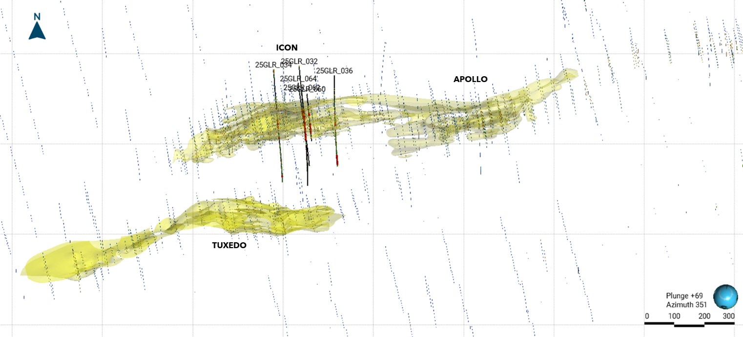 Figure 2. Plan view of drilling collars and traces.
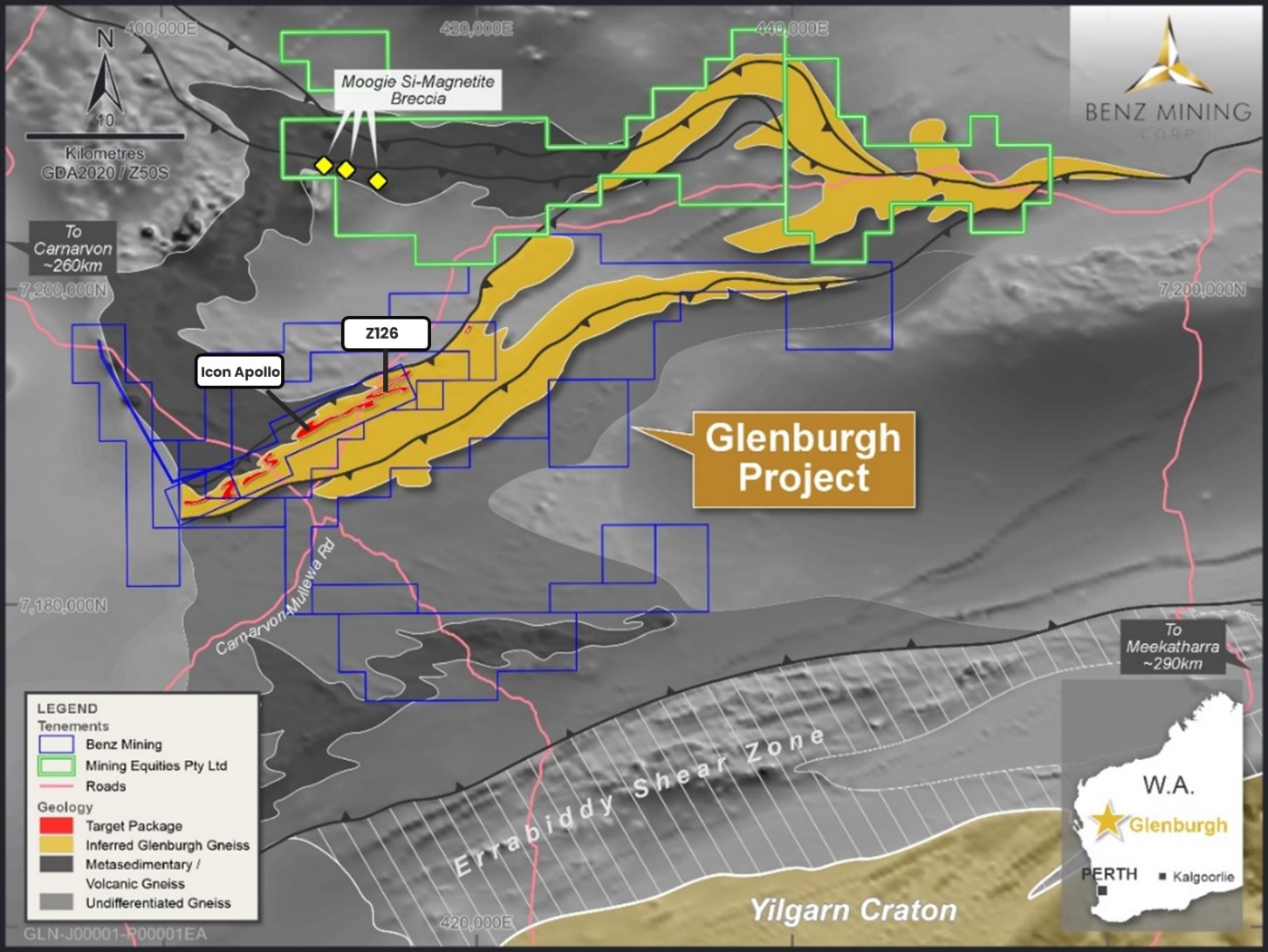 Figure 3. Glenburgh Project Geology overview.
This announcement has been approved for release by the Board of Benz Mining Corp.
For more information please contact:
Mark Lynch-Staunton
Chief Executive Officer
Benz Mining Corp.
E: This email address is being protected from spambots. You need JavaScript enabled to view it.
T: +61 8 6143 6702
About Benz Mining Corp.
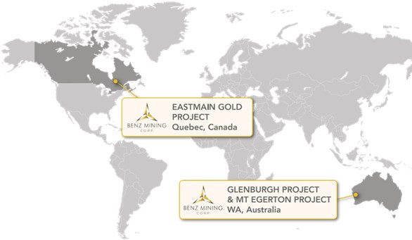
Benz Mining Corp. (TSXV: BZ) (ASX: BNZ) is a pure-play gold exploration company dual-listed on the TSX Venture Exchange and Australian Securities Exchange. The Company owns the Eastmain Gold Project in Quebec, and the recently acquired Glenburgh and Mt Egerton Gold Projects in Western Australia.
Benz's key point of difference lies in its team's deep geological expertise and the use of advanced geological techniques, particularly in high-metamorphic terrane exploration. The Company aims to rapidly grow its global resource base and solidify its position as a leading gold explorer across two of the world's most prolific gold regions.
The Glenburgh Gold Project features a Historical (for the purposes of NI 43-101) Mineral Resource Estimate of 16.3Mt at 1.0 g/t Au (510,100 ounces of contained gold)1. A technical report prepared under NI 43-101- Standards of Disclosure for Mineral Projects (NI 43-101) titled "NI 43-101 Technical Report on the Glenburgh - Egerton Gold Project, Western Australia" with an effective date of 16 December 2024 has been filed with the TSX Venture Exchange and is available under the Company's profile at www.sedarplus.ca.
The Eastmain Gold Project in Quebec hosts a Mineral Resource Estimate dated effective May 24, 2023 and prepared in accordance with NI 43-101 and JORC (2012) of 1,005,000 ounces at 6.1g/t Au2, also available under the Company's profile at www.sedarplus.ca, showcasing Benz's focus on high-grade, high-margin assets in premier mining jurisdictions.
For more information, please visit: https://benzmining.com/.
Qualified Person's Statement (NI 43-101)
The disclosure of scientific or technical information in this news release is based on, and fairly represents, information compiled by Mr Mark Lynch-Staunton, who is a Qualified Person as defined by NI 43-101 and a Member of Australian Institute of Geoscientists (AIG) (Membership ID: 6918). Mr Lynch-Staunton has reviewed and approved the technical information in this news release. Mr Lynch-Staunton owns securities in Benz Mining Corp.
Historical Mineral Resource Estimates
All mineral resource estimates in respect of the Glenburgh Gold Project in this news release are considered to be "historical estimates" as defined under NI 43-101. These historical estimates are not considered to be current and are not being treated as such. These estimates have been prepared in accordance with the Australasian Code for Reporting of Exploration Results, Mineral Resources and Ore Reserves prepared by the Joint Ore Reserves Committee of the Australasian Institute of Mining and Metallurgy, Australian Institute of Geoscientists and Minerals Council of Australia (JORC Code) and have not been reported in accordance with NI 43-101. A qualified person (as defined in NI 43-101) (Qualified Person) has not done sufficient work to classify the historical estimates as current mineral resources. A Qualified Person would need to review and verify the scientific information and conduct an analysis and reconciliation of historical data in order to verify the historical estimates as current mineral resources.
Forward-Looking Statements
Statements contained in this news release that are not historical facts are "forward-looking information" or "forward looking statements" (collectively Forward-Looking Information) as such term is used in applicable Canadian securities laws. Forward-Looking Information includes, but is not limited to, disclosure regarding the exploration potential of the Glenburgh Gold Project and the anticipated benefits thereof, planned exploration and related activities on the Glenburgh Gold Project. In certain cases, Forward-Looking Information can be identified by the use of words and phrases or variations of such words and phrases or statements such as "anticipates", "complete", "become", "expects", "next steps", "commitments" and "potential", in relation to certain actions, events or results "could", "may", "will", "would", be achieved. In preparing the Forward-Looking Information in this news release, the Company has applied several material assumptions, including, but not limited to, that the accuracy and reliability of the Company's exploration thesis in respect of additional drilling at the Glenburgh Gold Project will be consistent with the Company's expectations based on available information; the Company will be able to raise additional capital as necessary; the current exploration, development, environmental and other objectives concerning the Company's Projects (including Glenburgh and Mt Egerton Gold Projects) can be achieved; and the continuity of the price of gold and other metals, economic and political conditions, and operations.
Forward-looking information is subject to a variety of risks and uncertainties and other factors that could cause plans, estimates and actual results to vary materially from those projected in such forward-looking information. Factors that could cause the forward-looking information in this news release to change or to be inaccurate include, but are not limited to, the early stage nature of the Company's exploration of the Glenburgh Gold Project, the risk that any of the assumptions referred to prove not to be valid or reliable, that occurrences such as those referred to above are realized and result in delays, or cessation in planned work, that the Company's financial condition and development plans change, and delays in regulatory approval, as well as the other risks and uncertainties applicable to the Company as set forth in the Company's continuous disclosure filings filed under the Company's profile at www.sedarplus.ca and www.asx.com.au. Accordingly, readers should not place undue reliance on Forward-Looking Information. The Forward-looking information in this news release is based on plans, expectations, and estimates of management at the date the information is provided and the Company undertakes no obligation to update these forward-looking statements, other than as required by applicable law.
NEITHER THE TSX VENTURE EXCHANGE NOR ITS REGULATION SERVICES PROVIDER (AS THAT TERM IS DEFINED IN THE POLICIES OF THE TSX VENTURE EXCHANGE) ACCEPTS RESPONSIBILITY FOR THE ACCURACY OR ADEQUACY OF THIS RELEASE.
Appendix 1: Collar Table. Coordinates system: GDA94/MGA Zone 50
| Hole number | Easting | Northing | Elevation (m) | End Depth (m) | Dip | Azimuth |
| 25GLR_064 | 409586.94 | 7191507.83 | 293 | 366 | 58 | 158 |
| 25GLR_062 | 409603.42 | 7191477.59 | 293 | 420 | 63 | 161 |
| 25GLR_060 | 409621.68 | 7191475.74 | 292 | 216 | 63 | 161 |
| 25GLR_036 | 409701.46 | 7191553.84 | 293 | 402 | 60 | 170 |
| 25GLR_034 | 409498.66 | 7191542.61 | 292 | 530 | 61 | 164 |
| 25GLR_032 | 409580.42 | 7191568.88 | 292 | 432 | 59 | 163 |
Appendix 2: Significant Intercepts Tables.
Higher Grade Intercepts: A nominal 0.9g/t Au lower cut off has been applied to results, with no maximum internal dilution included unless otherwise stated.
| Hole ID | From (m) | To (m) | Length (m) | Au (ppm) |
| 25GLR_064 | 108 | 146 | 38 | 1.1 |
| 25GLR_064 | 178 | 185 | 7 | 1.7 |
| 25GLR_064 | 203 | 210 | 7 | 1.5 |
| 25GLR_062 | 84 | 88 | 4 | 1.4 |
| 25GLR_062 | 94 | 210 | 116 | 1.3 |
| 25GLR_060 | 69 | 71 | 2 | 2.0 |
| 25GLR_060 | 85 | 99 | 14 | 1.2 |
| 25GLR_060 | 135 | 179 | 44 | 2.2 |
| 25GLR_036 | 164 | 166 | 2 | 1.2 |
| 25GLR_036 | 202 | 204 | 2 | 1.2 |
| 25GLR_036 | 208 | 227 | 19 | 0.9 |
| 25GLR_036 | 352 | 395 | 43 | 0.9 |
| 25GLR_034 | 7 | 11 | 4 | 2.5 |
| 25GLR_034 | 175 | 179 | 4 | 2.0 |
| 25GLR_034 | 231 | 270 | 39 | 1.3 |
| 25GLR_034 | 309 | 311 | 2 | 1.3 |
| 25GLR_034 | 315 | 317 | 2 | 1.4 |
| 25GLR_034 | 494 | 504 | 10 | 2.8 |
| 25GLR_033 | 426 | 512 | 86 | 1.1 |
| 25GLR_032 | 175 | 216 | 41 | 1.6 |
| 25GLR_032 | 282 | 285 | 3 | 2.0 |
| 25GLR_032 | 341 | 343 | 2 | 1.3 |
Bulk potential intercepts reported with a nominal 0.3g/t Au lower cut off with no maximum internal dilution length applied.
| Hold ID | From (m) | To (m) | Length (m) | Au (ppm) | Comment |
| 25GLR_064 | 107 | 224 | 117 | 0.7 | Ending in mineralisation |
| 25GLR_062 | 76 | 230 | 154 | 1.1 | Ending in mineralisation |
| 25GLR_060 | 66 | 200 | 134 | 1.0 | Ending in mineralisation |
| 25GLR_036 | 163 | 166 | 3 | 1.0 | Ending in mineralisation |
| 25GLR_036 | 194 | 400 | 206 | 0.5 | Ending in mineralisation |
| 25GLR_034 | 4 | 37 | 33 | 0.4 | Ending in mineralisation |
| 25GLR_034 | 149 | 179 | 30 | 0.3 | Ending in mineralisation |
| 25GLR_034 | 222 | 528 | 306 | 0.4 | Ending in mineralisation |
| 25GLR_032 | 157 | 429 | 272 | 0.5 | Ending in mineralisation |
Appendix 3: JORC Tables
JORC Code, 2012 Edition - Table 1 report template
Section 1 Sampling Techniques and Data
(Criteria in this section apply to all succeeding sections.)
| Criteria | Commentary |
| Sampling techniques |
|
| Drilling techniques |
|
| Drill sample recovery |
|
| Logging |
|
| Sub-sampling techniques and sample preparation |
|
| Quality of assay data and laboratory tests |
|
| Verification of sampling and assaying |
|
| Location of data points |
|
| Data spacing and distribution |
|
| Orientation of data in relation to geological structure |
|
| Sample security |
|
| Audits or reviews |
|
Section 2 Reporting of Exploration Results
(Criteria listed in the preceding section also apply to this section.)
| Criteria | Commentary |
| Mineral tenement and land tenure status |
|
| Exploration done by other parties |
|
| Geology |
|
| Drill hole Information |
|
| Data aggregation methods |
|
| Relationship between mineralisation widths and intercept lengths |
|
| Diagrams |
|
| Balanced reporting |
|
| Other substantive exploration data |
|
| Further work |
|
1 Indicated: 13.5Mt at 1.0g/t Au for 430.7koz; Inferred: 2.8Mt at 0.9g/t Au for 79.4koz. See Historical Mineral Resource Estimates, above
2 Indicated: 1.3Mt at 9.0g/t Au for 384koz; Inferred: 3.8Mt at 5.1g/t Au for 621koz