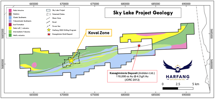
MONTREAL, May 28, 2025 (GLOBE NEWSWIRE) -- Harfang Exploration Inc. (TSX.V: HAR) (“Harfang” or the “Company”) is pleased to announce additional high-grade intercepts and the second batch of results from the 2025 winter diamond drill program (“Winter Drilling”). Winter Drilling focused on the Koval patented claims at its recently acquired and wholly owned Sky Lake Gold Project located in Ontario’s Pickle Lake Gold District (Figure 1).
The Company has intersected a high-grade mineralized interval interpreted to be the extension of the previously announced discovery (see press release dated May 14, 2025). This extension delineates a mineralized shoot that extends more than 250 metres downhole and remains open at depth. This second batch of drill results outlines a mineralized gold system and concludes the maiden drilling program at Sky Lake.
HIGHLIGHTS
- Headline interval of 4.5 g/t Au over 15.6 metres (incl. 7.5 g/t Au over 8.4 metres, incl. 35.6 g/t Au over 2.5 metres) in hole SLA-25-04.
- The Company has delineated a continuous high-grade mineralized shoot that is currently traced over 250 metres downhole and remains open at depth.
- Mineralized zones consist of quartz-sericite-biotite alteration envelopes with pyrite, pyrrhotite and arsenopyrite finely disseminated and in stringers, accompanied with quartz-tourmaline-carbonate veins.
- Harfang is planning a summer 2025 exploration program at Sky Lake to follow up on Winter Drilling.
Rick Breger, President and CEO of Harfang, commented, “We are pleased that this final batch of results from our winter drill program at Sky Lake is so compelling. It has become obvious to us that there may be a significant mineralized system at Koval. The regional geology, the project geology, and the information we have gleaned from the drill program all suggest that this shear zone was once very active and is fertile. The delineation of this first mineralized shoot is testament to this fertility. I would consider this maiden drill program a huge success and credit must be extended to the entire Harfang and Forage MultiDrilling teams for all their hard work and dedication.”
“In addition, we are very happy that this drill program instilled a high degree of confidence in the historical datasets. While we recognize the non-compliant nature of this data, the work was done by reputable groups and has been instrumental in guiding our exploration and the geologic interpretation of the Koval Zone. Our fully funded summer exploration program will not only include additional work at Koval, but we will also be working on other parts of the shear zone.”
Winter Drilling
From mid-March to early April 2025, Harfang completed a total of 1,338 metres of diamond drilling in six holes, centered on the Koval Zone (Figure 2). Today’s release includes assay results from the remaining three holes - SLA-25-04, -05, and -06, totalling 678 core samples (Table 1).
Winter Drilling was designed to test high-priority targets generated through the analyses of historical drill data using modern 3D geological modeling practices (the “Targeting Model”). A total of 77 historical drill holes, most of which date back to the early 1950’s (“Historical Data”), were used to guide initial drill targeting. Readers are cautioned that the Historical Data is not compliant with NI 43-101 due to its uncertain reliability and lack of QA/QC validation; drill core, pulp rejects, and assay certificates are not available. The Company believes the Historical Data remains relevant for exploration purposes, as it includes the only other source of subsurface information for the area. Additional data used to orient initial drill targeting included surface mapping and prospecting previously completed by NewOrigin Gold Corp.
Table 1: Sky Lake Project Drill Highlights
| Hole ID | From (m) | To (m) | Length (m) | Au (g/t) |
| SLA-25-04 | 290.85 | 306.45 | 15.60 | 4.54 |
| incl. | 292.25 | 300.60 | 8.35 | 7.52 |
| incl. | 295.65 | 298.15 | 2.50 | 35.59 |
| SLA-25-06 | 116.60 | 127.55 | 10.95 | 0.30 |
| SLA-25-05 | 147.15 | 152.00 | 4.85 | 0.6 |
| Reported May 14, 2025 | ||||
| SLA-25-03 | 58.50 | 76.45 | 17.95 | 6.96 |
| incl. | 63.80 | 72.00 | 8.20 | 10.28 |
| and incl. | 74.55 | 76.45 | 1.90 | 10.49 |
| 159.20 | 172.60 | 13.40 | 1.97 | |
| incl. | 160.20 | 163.85 | 3.65 | 4.86 |
| incl. | 161.20 | 162.00 | 0.80 | 11.70 |
| SLA-25-02 | 69.90 | 79.30 | 9.40 | 1.02 |
| incl. | 71.40 | 72.15 | 0.75 | 7.97 |
| SLA-25-01 | 102.20 | 102.70 | 0.50 | 5.36 |
| 142.35 | 146.25 | 3.90 | 1.14 | |
Note: Assays are not capped, and all lengths are reported as downhole intervals (true widths are yet to be determined)
Drill Results
Hole SLA-25-04 was designed to test the down-plunge extension of the shallow high-grade mineralization intersected in hole SLA-25-03, which returned 6.96 g/t Au over 17.95 metres. SLA-25-04 is the deepest hole of the program, with a total length of 372 metres.
Highlights from hole SLA-25-04 include: 4.54 g/t Au over 15.60 metres (from 290.85 m to 306.45 m), including 7.52 g/t Au over 8.35 metres (from 292.25 m to 300.60 m), including 35.59 g/t Au over 2.50 m (from 295.65 m to 298.15 m).
Similar to the previously released results, gold mineralization is associated with disseminated and stringer-hosted pyrite, pyrrhotite, and arsenopyrite, within strong quartz-sericite-biotite ± calcite-chlorite alteration, hosted in a foliated transition zone of greywacke and mafic volcanic rock. Quartz-sericite-biotite alteration is pervasive, often with 5% to 15% fine sulphide content in zones of intense sericite-biotite alteration (Figure 3).
Quartz-tourmaline-carbonate shear veins and folded quartz-carbonate-pyrite veins are key features of the gold-rich zone. The former are commonly coplanar with the ENE subvertical schistosity. The veining system highlights a complex structural setting within a shear zone.
Holes SLA-25-05 and -06 targeted shallow lateral extensions, respectively, 150 metres to the east and to the west of hole SLA-25-03. The best intercepts returned 0.30 g/t Au over 10.95 metres (from 116.60 m to 127.55 m) in hole SLA-25-06, and 0.60 g/t Au over 4.85 metres (from 147.17 m to 152.00 m) in hole SLA-25-05. Carbonate-biotite-sericite alteration, along with pyrite-pyrrhotite-arsenopyrite mineralization, and quartz-tourmaline-carbonate veins, suggest close proximity to an active hydrothermal system.
Mineralized Shoot Model at Koval
Winter Drilling has successfully led to the discovery of multiple mineralized zones. These results increase confidence in the Targeting Model which, going forward, will include the results from Winter Drilling. The inclusion of the Historical Data along with Harfang’s modern data will result in a robust dataset for Sky Lake.
By combining the data, the Company interprets two subparallel, east-trending mineralized zones within a multi-kilometre-long shear corridor: the northern "Red Zone" (Figure 4) and the southern "Yellow Zone". Both zones host moderately plunging pencil-shaped mineralized shoots associated with antimony, arsenic, and silver.
The Red Zone hosts the principal mineralized shoot at Koval, supported by high-grade intercepts in holes SLA-25-03 and SLA-25-04, which also aligned with the Historical Data. These combined datasets suggest a continuous, high-grade mineralized body that starts at surface, extends approximately 250 metres down-plunge, and remains open at depth.
Today’s results mark a significant advancement, uncovering the down-plunge continuity of high-grade mineralization at depth. The interpretation of surrounding lower-grade halos is supported by results from Winter Drilling and Historical Data. These characteristics reinforce the interpretation of a robust, structurally-controlled gold system, typical of Archean orogenic deposits in the Superior Province.
The Yellow Zone is located approximately 75 metres south of the Red Zone and across the shear corridor. Winter Drilling and the Historical Data suggest a mineralized shoot with a similarly plunging geometry with a more limited extent based on the data currently available.
Next Steps
Harfang is planning a summer 2025 exploration program at Sky Lake designed to follow up on Winter Drilling as well as conduct preliminary exploration on the reminder of the land package. This program will include prospecting, geological mapping, and channel sampling. This work will aim to improve the understanding of the geologic model, the structural environment, and evaluate the potential for additional mineralized shoots along the shear zone.
Geological Context
The Sky Lake property lies within the Archean Meen-Dempster greenstone belt of the Uchi Subprovince, part of the Superior Province (Figures 5 and 6). The area hosts arcuate, deformed greenstone belts dominated by mafic to intermediate volcanics intruded by granitic to ultramafic bodies.
At the Koval Zone, the stratigraphic sequence evolves from homogeneous amphibolite-rich mafic metavolcanic domain to the north to volcaniclastic and fine clastic metasediments, typically tuff, greywacke and siltstone toward the south. Thin garnet-rich silicate facies iron formations, along with felsic and mafic volcanic rocks are interbedded within the sedimentary assemblage. Mineralization typically occurs within the transition zones of sedimentary and volcanic units, areas also intruded by felsic to intermediate composition dykes. Metamorphism is upper greenschist to amphibolite facies.
Table 2: Sky Lake Project Drill Hole Location Information
| Hole ID | UTM East | UTM North | Elevation (m) | Azimuth (°) | Dip (°) | Length (m) |
| SLA-25-01 | 671181 | 5680417 | 387 | 339 | -46 | 168 |
| SLA-25-02 | 671066 | 5680545 | 382 | 157 | -45 | 183 |
| SLA-25-03 | 671136 | 5680558 | 363 | 156 | -45 | 186 |
| SLA-25-04 | 671301 | 5680356 | 379 | 337 | -55 | 372 |
| SLA-25-05 | 671304 | 5680476 | 384 | 339 | -46 | 201 |
| SLA-25-06 | 670998 | 5680502 | 390 | 152 | -50 | 228 |
Note: Coordinates are in NAD83 UTM Zone 15N.
The Sky Lake Property
The Sky Lake property covers 9,100 hectares (approximately 27 kilometres by 3 kilometres), comprising 446 mining cell, and 28 patented claims totalling 295 hectares. The project lies midway between the past-producing gold deposits of the Pickle Lake Gold District, the Dona Lake Mine to the northeast, and the Golden Patricia gold mine to the west. The Sky Lake property benefits from nearby infrastructure as the eastern edge the property flanks highway 599 and the local power transmission lines.
In September 2019, Ardiden Limited reported a JORC compliant inferred mineral resource at its Kasagiminnis (“Kas”) gold project totalling 110,000 ounces of gold grading 4.3 grams per tonne. The deposit consists of gold-bearing iron-formation. Kas is located approximately 6 kilometres to the northeast of the Koval deposit and is surrounded by mineral claims wholly owned by Harfang. The shear zone hosting the gold mineralization at Koval connects with the Kas deposit area.
Gold mineralization in the Pickle Lake district is typically associated with orogenic style structurally-controlled quartz veins and sulphide replacement zones near iron formations (orogenic gold), as seen at the past-producing Pickle Crow, Central Patricia, and Golden Patricia mines, which collectively produced over 2.6 million ounces of gold.
Drilling, Core Sampling Protocols, and Quality Control
The drilling program was carried out by Forage MultiDrilling Inc. of Rouyn-Noranda, Québec, utilizing NQ-diameter diamond drilling. Harfang partnered with Explo-Logik Inc. of Val-d’Or, Québec, to support the core logging and geotechnical program.
Drill core was transported daily from the drill site to the core logging facility in Pickle Lake, Ontario. Under the supervision of Harfang geologists, core was systematically logged, photographed, and split in half using a core splitter. One half of the core was retained on site for reference, while the other half was sampled at regular intervals based on geological observations.
All samples were securely bagged and transported to AGAT Laboratories in Thunder Bay, Ontario. Gold was analyzed by atomic absorption spectrometry following fire assay on a 30-gram split. Multielement analyses were performed using a four-acid digestion with ICP–OES/MS finish for a 50-element suite. Samples returning >10 g/t Au were reanalyzed using a gravimetric finish. Sample preparation and analytical procedures were carried out across various AGAT facilities in Thunder Bay and Calgary, that are ISO/IEC 17025 accredited. A strict QA/QC protocol was implemented, with one certified reference material (CRM), one blank sample, and one field duplicate inserted into the sample stream for every batch of 25 samples. QA/QC and data validation procedures were performed, and no material errors were detected.
Land Acknowledgement
Harfang respectfully acknowledges the traditional territory of the Mishkeegogamang Ojibway First Nation. We recognize their enduring presence and connection to these lands, which have been their home for countless generations. The Company is grateful for the opportunity to work here and is committed to conducting all activities in a way that respects their rights, culture, and traditional ways of life.
Qualified Person
Ludovic Bigot, P.Geo., VP Exploration of Harfang, has prepared and approved the technical information contained in this news release. Mr. Bigot is a qualified person within the meaning of National Instrument 43-101 on standards of disclosure for mineral projects.
About Harfang Exploration Inc.
Harfang Exploration Inc. is a well-financed technically driven mineral exploration company with the primary mission to discover ore deposits in Québec and Ontario. The Company is managed by an experienced team of industry professionals with a proven track record of success and controls a portfolio of highly prospective projects. Harfang is dedicated to best practices through engagement with all stakeholders and a commitment to the environment.
For further information, please contact:
Rick Breger, P.Geo.
President and CEO
This email address is being protected from spambots. You need JavaScript enabled to view it.
Cautionary Statement Regarding Forward-Looking Information
The information in this news release includes certain information and statements about management’s view of future events, expectations, plans and prospects that constitute forward-looking statements. These statements are based upon assumptions that are subject to significant risks and uncertainties. Because of these risks and uncertainties and as a result of a variety of factors, the actual results, expectations, achievements or performance may differ materially from those anticipated and indicated by these forward-looking statements. Any number of factors could cause actual results to differ materially from these forward-looking statements as well as future results. Although Harfang believes that the expectations reflected in forward-looking statements are reasonable, it can give no assurances that the expectations of any forward-looking statements will prove to be correct. Except as required by law, Harfang disclaims any intention and assumes no obligation to update or revise any forward-looking statements to reflect actual results, whether as a result of new information, future events, changes in assumptions, changes in factors affecting such forward-looking statements or otherwise.
Neither the TSX Venture Exchange nor its Regulation Services Provider (as that term is defined in the policies of the TSX Venture Exchange) accepts responsibility for the adequacy or accuracy of this release.
Figure 1. Location map of the Sky Lake Project and surroundings.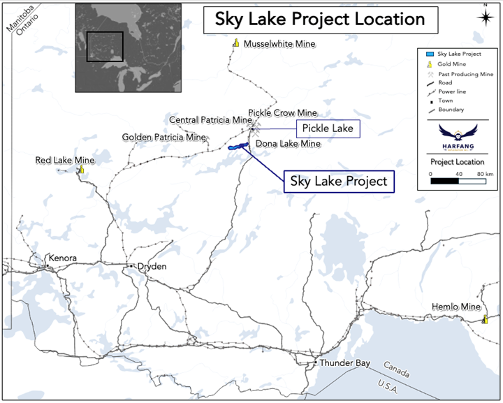
Figure 2. Assay results and drill hole traces of the 2025 winter diamond drill program. Holes released today are displayed with a yellow border.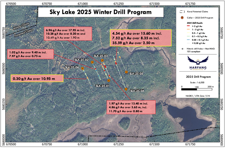
Figure 3. Core photo of hole SLA-25-04 showing headline interval of 4.54 g/t Au over 15.60 metres (from 290.85 metres to 306.45 metres), including 7.52 g/t Au over 8.35 metres (from 292.25 m to 300.60 m).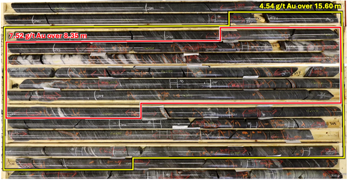
Figure 4. Longitudinal section which includes results from Winter Drilling and Historical Data.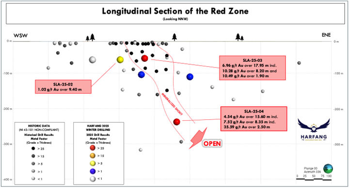
Figure 5. Regional geology map of the Sky Lake Project.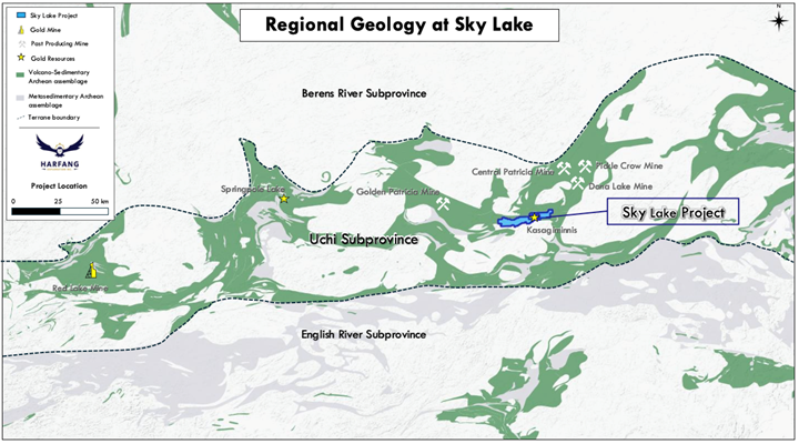
Figure 6. Project geology map of the Sky Lake Project.