Highlights:
- Extended gold mineralization 100 metres to the west at North Stock in RSR-019 that intersected 0.95 g/t Au over 22.9 metres and hosted visible gold.
- Hole RSR-011, a 130 metre step-out hole, extends gold mineralization to the west, returning 0.88 g/t Au over 18.3 metres and 0.59 g/t Au over 53.3 metres. System remains open to the west.
- Hole RSR-014, highlighted by 0.88 g/t Au over 27.4 metres and 0.40 g/t Au over 64.0 metres, expanded the southwestern extension of the North Stock deposit by 75 metres.
- Hole RSC-186 was a 200 metre step-out hole to the east from the North Stock deposit and demonstrated the system continues and remains open.
- The Company has completed approximately 90% of the 2017 drill program or 43 holes and has three holes that remain to be drilled. The program is expected to be completed in the coming weeks and assays will be released as they become available.
SASKATOON, Saskatchewan, Nov. 14, 2017 (GLOBE NEWSWIRE) -- GFG Resources Inc. (TSX-V:GFG) (OTCQB:GFGSF) (“GFG” or the “Company”) announces further drill results from its ongoing 2017 exploration drill program at its 100% controlled, Rattlesnake Hills Gold Project in Wyoming, United States. The 2017 exploration program was designed to take an aggressive, district scale approach by testing beyond the boundaries of historic drilling and evaluating new targets in the district that have similar geologic traits to North Stock and Antelope Basin. Year to date, step-out drilling has successfully proven that the known gold deposits remain open and continue to grow.
Brian Skanderbeg, President and CEO, commented, “Step-out drilling in the brownfield environment continues to expand gold mineralization and outline the scale of the deposits. We have now demonstrated that the North Stock deposit has a strike length of approximately 750 metres and remains open to the west and southwest. Drilling in the Middle Ground between North Stock and Antelope Basin continues to return economic intercepts which highlight the potential to link the two deposits and outline a system that is approximately 1.1 kilometres in length. Based on the exploration success in the brownfield areas, we have reallocated some greenfield drilling metres to focus on the Middle Ground and along the eastern flank of Antelope Basin. Drill success in these areas would materially impact our geological model and positively impact the maiden resource estimate in H1 2018. Our 2017 drilling program is nearly complete and with approximately 50% of the assays pending, we remain confident that we will continue to see expansion in the brownfield target areas and expect to provide further results in the near future.”
Table 1: Recent Highlights from the 2017 Drill Program from Rattlesnake Hills Gold Project.
| Hole ID | From (m) | To (m) | Length (m) | Au (g/t) | Cut Off (g/t) |
| RSR-011 | 129.5 | 147.8 | 18.3 | 0.88 | 0.20 |
| incl. | 129.5 | 137.2 | 7.6 | 1.69 | 0.50 |
| 172.2 | 176.8 | 4.6 | 0.87 | 0.20 | |
| 190.5 | 195.1 | 4.6 | 0.50 | 0.20 | |
| 214.9 | 219.5 | 4.6 | 0.77 | 0.20 | |
| 251.5 | 304.8 | 53.3 | 0.59 | 0.20 | |
| incl. | 294.1 | 303.3 | 9.2 | 0.94 | 0.50 |
| RSR-014 | 30.5 | 50.3 | 19.8 | 0.26 | 0.20 |
| 80.8 | 108.2 | 27.4 | 0.88 | 0.20 | |
| incl. | 80.8 | 106.7 | 25.9 | 0.92 | 0.50 |
| 132.6 | 166.1 | 33.5 | 0.45 | 0.20 | |
| incl. | 132.6 | 141.7 | 9.1 | 1.10 | 0.50 |
| 222.5 | 298.7 | 76.2 | 0.36 | 0.20 | |
| incl. | 228.6 | 236.2 | 7.6 | 0.91 | 0.50 |
| incl. | 251.5 | 254.5 | 3.1 | 0.71 | 0.50 |
| RSR-018 (water well) | 44.2 | 50.3 | 6.1 | 1.22 | 0.20 |
| 91.4 | 94.5 | 3.1 | 1.54 | 0.20 | |
| RSR-019 | 254.5 | 277.4 | 22.9 | 0.95 | 0.20 |
| incl. | 269.8 | 272.8 | 3.1 | 5.07 | 0.50 |
| RSC-186 | 147.8 | 158.5 | 10.7 | 0.39 | 0.20 |
| 211.8 | 216.4 | 4.6 | 1.23 | 0.20 | |
| 365.8 | 371.9 | 6.1 | 0.83 | 0.20 | |
| incl. | 368.8 | 371.9 | 3.1 | 1.51 | 0.50 |
*Gold intervals reported in the above table are based on a 0.20 g/t or 0.50 g/t Au cutoff and may include waste or low-grade intervals of up to 9.5 metres. Weighted averaging has been used to calculate all reported intervals. True widths are estimated at 60-100% of drilled thickness.
Drill Results Commentary
RSR-011 was planned to extend the middle ground area and offset mineralization seen in hole RSR-004 that returned 0.60 g/t over 73.2 metres in 2016. Mineralization is associated with zones of stronger potassic alteration and disseminated pyrite. The results extended mineralization by 130 metres and suggest the Middle Ground continues to remain open towards the west and north where additional holes have been completed.
RSR-014 tested the contact between the heterolithic breccia and the Precambrian schist on the west side of North Stock. The hole returned 0.88 g/t Au over 27.4 metres, 0.82 g/t Au over 13.7 metres and 0.40 g/t Au over 64.0 metres; extending mineralization 75 metres to the southwest from historic drilling. A broad mixed zone of heterolithic and monolithic breccia and schist (110 to 250 metres) was intersected in this hole and this mixed zone contained most of the mineralized intercepts.
RSR-018 was drilled as a shallow, vertical water well. The hole passed through trachyandesites and breccia before ending in phonolite. The mineralization was primarily found along the contacts of these three units.
RSR-019 tested the extension of mineralization towards the west from the North Stock deposit. It intersected several zones of fault-bounded, heterolithic breccia and phonolite before ending in schist. The heterolithic breccia returned and intercept of 0.95 g/t Au over 22.9 metres, extending mineralization 100 metres to the west of hole RSC-188 that returned 0.45 g/t Au over 114.0 metres. Potassic alteration was seen in all breccias and schists, ranging up to strong. Visible gold was observed in the interval from 269.8 to 271.3 metres. This is significant as it indicates that higher grade intervals and heterolithic breccias extend significantly along strike to the west of the North Stock deposit.
RSC-186 was a 200 metre step-out hole designed to test the eastern extension of the North Stock deposit. It intersected schist, heterolithic breccia, trachyandesite and monolithic schist breccia. Gold mineralization is spatially related with carbonate-altered breccia units and the contact zones with the schists.
BJR-002 was designed to test the eastern side of the strong Au soil anomaly at the Blackjack area. The drill hole intersected weak to moderately propyllitically-altered granite with only a few zones of weak to moderately potassically altered granite with thin zones showing strong to potassically altered granite.
Greenfield drilling in the Blackjack area did test several VTEM anomalies however, the results did not intercept any significant zones of mineralization. The focus in the Blackjack area will be on further testing the 750 metre by 400 metre gold-silver soil anomaly where drilling was successful at identifying broad zones of gold and silver mineralization.
To date, the Company has completed 90% or 13,100 metres of its 2017 drill program or 43 holes with three holes remaining. Drilling is expected to be completed in the coming weeks and the Company will provide further drill results prior to year end. In addition to the drill program, further metallurgical test and geological and resource modelling will be completed to support a maiden National Instrument 43-101 resource estimate that is expected to be announced in the first half of 2018.
Figure 1: Plan map of North Stock and Antelope Basin 2017 drill results, planned hole locations and historic drill highlights
Figure 2: Plan map of Blackjack 2017 drill results, planned hole locations and historic drill highlights
Figure 3: Regional map of the Rattlesnake Hills Gold Project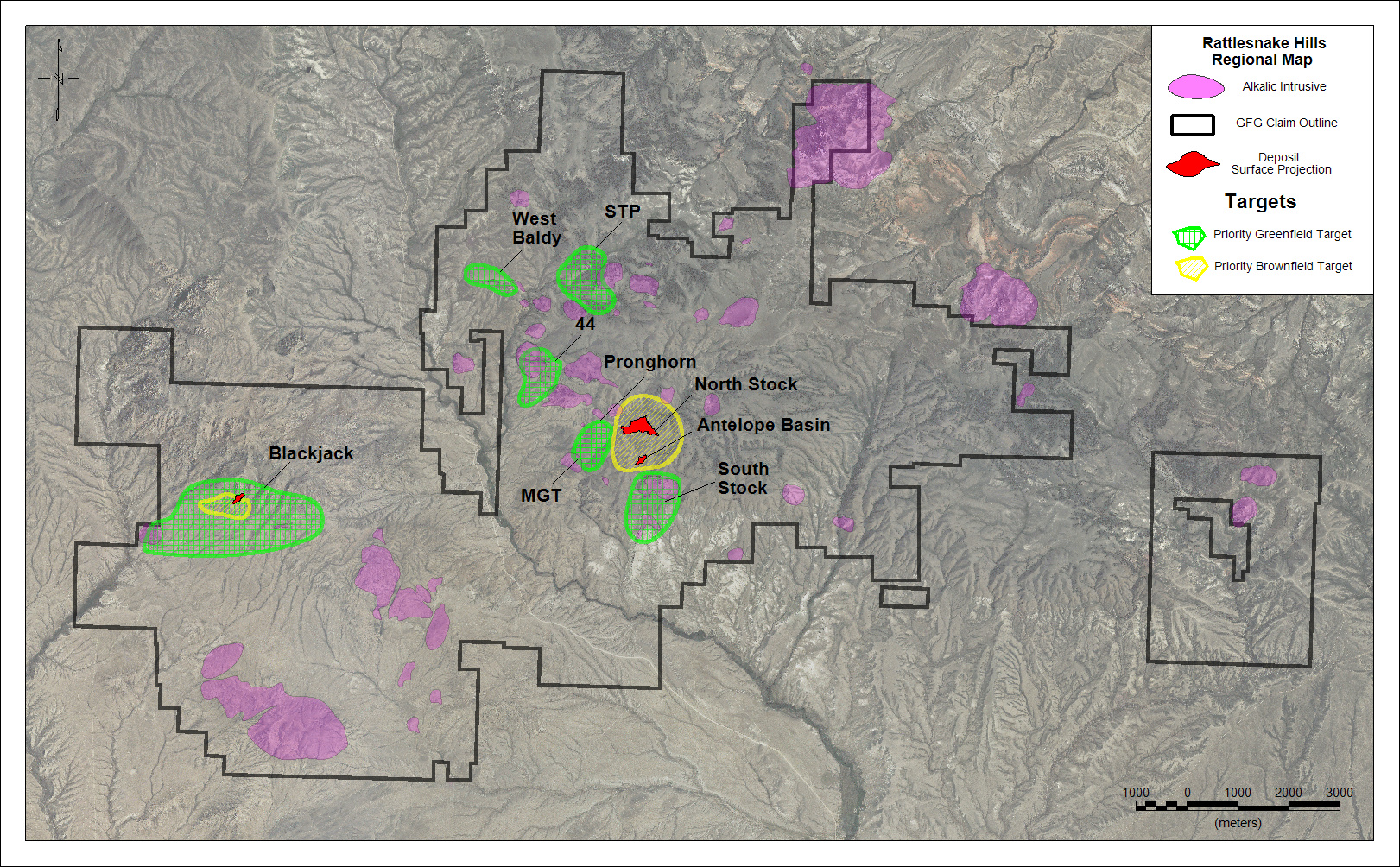
Table 2: Complete List of Recent 2017 Exploration Results.
| Hole ID | From (m) | To (m) | Length (m) | Au (g/t) | Cut Off (g/t) |
| RSR-005 (water well) | no significant interval | ||||
| RSR-011 | 129.5 | 147.8 | 18.3 | 0.88 | 0.20 |
| incl. | 129.5 | 137.2 | 7.6 | 1.69 | 0.50 |
| 172.2 | 176.8 | 4.6 | 0.87 | 0.20 | |
| 190.5 | 195.1 | 4.6 | 0.50 | 0.20 | |
| 214.9 | 219.5 | 4.6 | 0.77 | 0.20 | |
| 251.5 | 304.8 | 53.3 | 0.59 | 0.20 | |
| incl. | 294.1 | 303.3 | 9.2 | 0.94 | 0.50 |
| RSR-014 | 30.5 | 50.3 | 19.8 | 0.26 | 0.20 |
| 80.8 | 108.2 | 27.4 | 0.88 | 0.20 | |
| incl. | 80.8 | 106.7 | 25.9 | 0.92 | 0.50 |
| 132.6 | 166.1 | 33.5 | 0.45 | 0.20 | |
| incl. | 132.6 | 141.7 | 9.1 | 1.10 | 0.50 |
| 222.5 | 298.7 | 76.2 | 0.36 | 0.20 | |
| incl. | 228.6 | 236.2 | 7.6 | 0.91 | 0.50 |
| incl. | 251.5 | 254.5 | 3.1 | 0.71 | 0.50 |
| RSR-015 (water well) | no significant interval | ||||
| RSR-018 (water well) | 44.2 | 50.3 | 6.1 | 1.22 | 0.20 |
| 91.4 | 94.5 | 3.1 | 1.54 | 0.20 | |
| RSR-019 | 254.5 | 277.4 | 22.9 | 0.95 | 0.20 |
| incl. | 269.8 | 272.8 | 3.1 | 5.07 | 0.50 |
| RSC-186 | 147.8 | 158.5 | 10.7 | 0.39 | 0.20 |
| 211.8 | 216.4 | 4.6 | 1.23 | 0.20 | |
| 365.8 | 371.9 | 6.1 | 0.83 | 0.20 | |
| incl. | 368.8 | 371.9 | 3.1 | 1.51 | 0.50 |
| BJR-002 | 0.0 | 7.6 | 7.6 | 0.35 | 0.20 |
| 153.9 | 181.4 | 27.4 | 0.20 | 0.20 | |
| BJR-006 | 64.0 | 83.8 | 19.8 | 0.25 | 0.20 |
| BJR-007 | no significant interval | ||||
| BJR-008 | no significant interval | ||||
| BJR-009 | no significant interval | ||||
| BJR-010 | no significant interval | ||||
| BJR-011 | no significant interval | ||||
*Gold intervals reported in the above table are based on a 0.20 g/t or 0.50 g/t Au cutoff and may include waste or low-grade intervals of up to 9.5 metres. Weighted averaging has been used to calculate all reported intervals. True widths are estimated at 60-100% of drilled thickness.
Qualified Persons
Brian Skanderbeg, P.Geo. and M.Sc., President and CEO, is the Qualified Person for the information contained in this press release and is a Qualified Person within the meaning of National Instrument 43-101.
GFG Resources Inc. is a publicly traded precious metals exploration company headquartered in Saskatoon, Saskatchewan, Canada, whose shares trade on the TSX Venture Exchange (GFG) and on the OTCQB (GFGSF). The Company controls 100% of the Rattlesnake Hills Gold Project, a district scale gold exploration project located approximately 100 kilometres southwest of Casper, Wyoming, U.S. The geologic setting, alteration and mineralization seen in the Rattlesnake Hills are similar to other gold deposits of the Rocky Mountain alkaline province which, collectively, have produced over 50 million ounces of gold.